Kermanshah province facts for kids
Quick facts for kids
Kermanshah
استان کرمانشاه
|
|
|---|---|

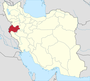
Location of Kermanshah province in Iran
|
|
| Country | Iran |
| Region | 4th Region |
| Capital | Kermanshah |
| Counties | 14 |
| Area | |
| • Total | 24,998 km2 (9,652 sq mi) |
| Population
(2016)
|
|
| • Total | 1,952,434 |
| • Density | 78.1036/km2 (202.287/sq mi) |
| Demonym(s) | Kermanshahi |
| Time zone | UTC+03:30 (IRST) |
| ISO 3166 code | IR-05 |
| Main language(s) | Kurdish local Persian official |
| HDI (2017) | 0.796 high · 14th |
| Kermanshah Province Historical Population | ||
|---|---|---|
| Year | Pop. | ±% |
| 1996 | 1,778,596 | — |
| 2006 | 1,879,385 | +5.7% |
| 2011 | 1,945,227 | +3.5% |
| 2016 | 1,952,434 | +0.4% |
| amar.org.ir | ||
Kermanshah Province (Persian: استان كرمانشاه, romanized: Ostān-e Kermanšah, Kurdish: پارێزگای کرماشان, romanized: Parêzgeha Kirmaşan) is one of Iran's 31 provinces. It is located in western Iran and shares a border with Iraq. The capital city of the province is Kermanshah.
The province has had different names over time. From 1969 to 1986, it was called Kermanshahan. Then, from 1986 to 1995, it was known as Bakhtaran.
In 2016, the population of Kermanshah Province was about 1.95 million people. Most people in the province are Shia Muslims. There are also smaller groups of Sunni Muslims and followers of Yarsani.
Contents
Exploring Kermanshah's Geography
Kermanshah Province is in the western part of Iran. It shares borders with several other Iranian provinces: Kurdistan, Hamadan, Lorestan, and Ilam.
It also borders three areas in Iraq: Halabja, Sulaymaniyah, and Diyala.
Some of the main cities and towns in the province, besides the capital city of Kermanshah, include Eslamabad-e Gharb, Gilan-e Gharb, Harsin, Javanrud, Kangavar, Paveh, Qasr-e Shirin, Ravansar, Sahneh, Sarpol-e Zahab, and Sonqor.
Kermanshah's Climate: Weather Patterns
Kermanshah Province has a moderate and mountainous climate. This is because it is located between cold and warm regions.
Winters usually have a lot of rain. Summers are moderately warm. The area gets about 500 millimeters of rain each year. In the hottest months, the average temperature is above 22 °C (72 °F).
A Journey Through Kermanshah's History

Kermanshah has a very old history, going back to the Stone Age. Many caves in the area have remains from the Paleolithic period (Old Stone Age). Some of these caves are near Bisetun and north of Kermanshah city.
The first known remains of Neanderthal people in Iran were found in Bisitun Cave. Other important Middle Paleolithic sites include Do-Ashkaft Cave, Kobeh, Warwasi, and Mar Tarik.
Kermanshah also has many sites from the Neolithic period (New Stone Age). The most famous ones are Ganj Dareh, Sarab, and Asiab. At Ganj Dareh, scientists found the earliest proof that goats were tamed by humans.
In 2009, an even older discovery was made in Sahneh. Researchers found what they believe is the oldest prehistoric village in the Middle East, dating back to 9800 B.C.
Ancient Empires and Royal Residences
The ancient monuments in Kermanshah show two important periods: the Achaemenid and Sassanid empires.
Some stories say that a mythical ruler named Pishdadian founded the city. Others say Tahmores Divband built it. Another idea is that Bahram IV of the Sassanid dynasty built it in the 4th century CE.
Kermanshah became very important during the rule of Hormizd IV and Khosrau I of the Sassanids. Later, it became a secondary home for the royal family.
Challenges and Conflicts Over Time
The city was badly damaged during the Arab invasions. However, it recovered and grew a lot during the Safavid period.
When the Afghan army attacked and Isfahan fell, Kermanshah was almost completely destroyed by the Ottoman invasion.
During the Iran–Iraq War, the province saw heavy fighting. Many towns and cities were severely damaged. Some, like Sar-e Pol-e Zahab and Qhasr-e-Shirin, were almost completely destroyed.
In November 2017, a large earthquake hit the Iran-Iraq border. More than 600 people in Kermanshah were killed.
In December 2017, Kermanshah was one of several Iranian provinces where protests broke out.
Kermanshah's Economy: Trade and Products
Kermanshah Province has a long border with Iraq, stretching 371 kilometers (230 miles). There are five official border markets in the province. Three of these are next to the Kurdish part of Iraq, and two are next to the Iraqi central government areas (Khosravi, Sumar).
Kermanshah is one of Iran's top five exporters of non-oil products. About 30% to 35% of these exports are products made in the province itself. The largest share of exports goes through the Parviz border, which is next to Iraqi Kurdistan. The Khosravi and Sumar borders also handle a lot of trade.
In the fiscal year 2021-2022, exports from Kermanshah Province reached $2.7 billion. This was a 15% increase from the previous year. Kermanshah's share of Iran's total exports was 10% by weight and 12% by value. The province's share of all exports to Iraq was 53%.
Non-oil exports from Kermanshah include things like tomatoes, tomato paste, air conditioners, cheese, industrial oils, biscuits, different types of melons, watermelons, tiles, ceramics, plastic bags, marble, yogurt, milk, cream, cucumbers, eggplants, apples, and melamine dishes.
Local Products and Crafts
Kermanshah is famous for several unique products:
- Persian Carpets: A special type of Persian carpet is named after the region.
- Nan-e Berenji: These are famous sweets made from rice.
- Roghan Kermanshahi: This is a special kind of oil, also known as Rüne Dân locally.
- Klash: This is a high-quality type of Giveh, a traditional Iranian shoe.
Discovering Kermanshah's Historical Attractions
Kermanshah has many interesting places to visit, from ancient times to modern parks and museums. Here are some of the most popular sites:
Bisotun: Ancient Inscriptions and Art

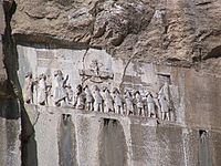
The Darius the Great's inscription at Bisotun is very old, dating back to 522 BCE. It is located high up in the mountains, about 1300 meters (4,265 feet) high. This site is one of the most famous in Near Eastern archeology.
Bisotun is a UNESCO World Heritage Site. The Behistun inscription was very important for understanding Old Persian cuneiform writing. It is a trilingual inscription, meaning it is written in three languages: Old Persian, Elamite, and Akkadian. This helped experts decode the ancient script, much like the Rosetta Stone helped with Egyptian hieroglyphs.
Above the inscription, there is a carving that shows Darius facing nine rebels who challenged his rule. At the king's feet lies Gaumata, a person who tried to take power. This important historical document is located here because Gaumata was from Medea, and Behistun was on the main road between Medea and Parsa during the Achaemenid times.
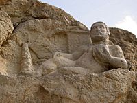
Bisotun also has three carvings at the bottom of the hill from the Parthian era. One of these shows the god Bahram as the Greek hero Hercules. He is shown relaxing with a cup in his hand, a club at his feet, and a lion skin under him. Since this site was on an old highway, this life-size rock sculpture might show Bahram as the protector of travelers.
Taq-e Bostan: Royal Rock Reliefs
The rock carvings at Taq-e Bostan are about 4 kilometers (2.5 miles) northeast of Kermanshah. Here, a spring flows from a mountain cliff into a large pool.
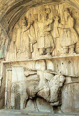
One of the most impressive carvings is inside the largest cave (called an ivan). It shows the Sassanid king Khosrau II (591–628 CE) on his favorite horse, Shabdiz. Both the horse and the rider are wearing full battle armor.
On the sides of the ivan are two hunting scenes. One shows a royal boar hunt, and the other shows the king hunting deer. In the boar hunt, elephants chase boars out of a marshy lake for the king, who is ready with his bow and arrow. Female musicians follow in other boats. These royal hunting scenes are like stone murals and are some of the most vivid Iranian rock carvings.
The Taq-e Bostan carvings are not only from the Sassanid era. An upper carving shows the 19th-century Qajar king Fath-Ali Shah holding court.
Kangavar Archaeological Complex: Anahita Temple
Kangavar is home to the remains of a large building in the Greek style, built on a raised platform. The parts that are still visible date back to early Sassanid times. However, the platform itself might be several centuries older.
When excavations started in 1968, people thought this complex was the temple of Anahita at Concobar (the Greek name for Kangavar). Anahita was a goddess of fertility, healing, and wisdom. Even though archaeological findings have shown otherwise, the idea that it was her temple has made it a popular tourist spot.
This large building was made of huge blocks of cut stone. It had an impressive entrance with two staircases facing each other. This design might have been inspired by the Apadana in Persepolis.
Higher Education in Kermanshah
Kermanshah is home to several important universities and research centers:
- Kermanshah University of Medical Sciences
- Razi University
- Islamic Azad University of Kermanshah
Notable People from Kermanshah
Many famous people have come from the Kermanshah region:
- Al-Dinawari: A renowned scientist and writer from the 9th century, born in Dinawar (north-east of Kermanshah). He wrote many books on astronomy, botany, and history.
- Doris Lessing: A British author and Nobel prize winner, born in Kermanshah. Her father, a British army officer, was stationed there when she was born.
- Mirza Ahmad Khan Motazed-Dowleh Vaziri: He set up the first printing office and founded the first private school in Kermanshahan.
- Guity Novin: A painter and graphic designer who started the Transpressionism art movement. She was born in Kermanshah.
- Abdul Qader Gailani: A famous Sufi Scholar, born in the region.
See also
 In Spanish: Provincia de Kermanshah para niños
- Kalhor
 | Bessie Coleman |
 | Spann Watson |
 | Jill E. Brown |
 | Sherman W. White |


