
South Khorasan province facts for kids
Quick facts for kids
South Khorasan Province
استان خراسان جنوبی
|
|
|---|---|
 |
|

Location of South Khorasan province in Iran
|
|
| Country | Iran |
| Region | Region 5 |
| Capital | Birjand |
| Counties | 11 |
| Area | |
| • Total | 151,913 km2 (58,654 sq mi) |
| Population
(2016)
|
|
| • Total | 768,898 |
| • Density | 5.061436/km2 (13.10906/sq mi) |
| Time zone | UTC+03:30 (IRST) |
| ISO 3166 code | IR-29 |
| Main language(s) | Persian |
| HDI (2017) | 0.757 high · 27th |
| Website | sko.ir |
South Khorasan Province (Persian: استان خراسان جنوبی Ostān-e Khorāsān-e Jonūbī) is one of the 31 provinces of Iran. It is located in the eastern part of the country. Birjand is the main city and capital of the province.
In 2016, about 768,898 people lived in South Khorasan province. This area used to be part of an older region called Quhistan. Historically, Quhistan was a unique place with its own culture and environment.
South Khorasan was created in 2004 when the larger Khorasan province was divided into three new provinces. At first, South Khorasan included only Birjand County and a few nearby areas. Later, more cities and territories from the old Quhistan region, like Qaen and Ferdows, joined South Khorasan. Today, it has 11 counties.
Contents
A Look at South Khorasan's Past

The larger region of Greater Khorasan has seen many different rulers and groups throughout history. People from Arab, Turk, Mongol, and Afghan tribes have all influenced the area over time.
Ancient geographers, who studied the Earth, said that Iran ("Iran-Shahr") was divided into eight parts. The biggest and most successful part was Greater Khorasan. The city of Esfarayen, located in this province, was an important place for Aryan tribes when they first came to Iran.
The Parthian empire, an ancient Iranian power, was based near Merv in Khorasan for many years. During their time, Esfarayen was a key village in the Nishapur area.
Later, during the Sassanid dynasty, a military leader called a "Spahbod" governed the province. There were also four "margraves" who each commanded one of the four sections of the province.
When the Muslim Arabs arrived in 651 AD, they divided Khorasan into four parts. Each part was named after its largest city: Nishapur, Merv, Herat, and Balkh.
The region was controlled by the Abbasid family until 820 AD. After that, Iranian groups like the Taherid clan and the Samanid dynasty took over.
In 994 AD, Mahmud of Ghazni conquered Khorasan. Then, in 1037 AD, Toghrül, the first ruler of the Seljuq empire, took control of Nishapur.
Khorasan faced more changes when it was conquered by the Khwarazmids in 1157 AD. Around the same time, the Mongols also attacked, and Khorasan became part of the Mongol Ilkhanate empire.
In the 14th century, a group called the Sarbedaran movement started in Sabzevar, fighting for independence. In 1468, Tamerlane took over Khorasan, and the city of Herat became his capital.
In 1507, Uzbek tribes occupied Khorasan. After Nader Shah died in 1747, parts of the region were briefly controlled by Afghans.
During these times, Birjand was a small part of Quhistan. Quhistan's main cities were Toon (now Ferdows) and Qaen. Birjand grew much larger in recent centuries, especially during the Qajar dynasty, becoming an important city in the region.
This area was also a safe place for groups like the Ismailis and for Arab refugees escaping problems with the Abbasid caliphate. You can still find signs of the ancient Zoroastrian religion here.
In 1824, Herat became independent for a few years. The Persians tried to take the city in 1837 but the British helped the Afghans stop them. In 1856, the Persians tried again and briefly recaptured Herat. This led to the Anglo-Persian War. The war ended in 1857 with the Treaty of Paris, and Persian troops left Herat. Afghanistan took Herat back in 1863.
Khorasan was Iran's largest province until it was divided into three new provinces on September 29, 2004. These new provinces are Razavi Khorasan, North Khorasan, and South Khorasan.
How South Khorasan is Organized

South Khorasan province is divided into several smaller areas called counties. Each county has its own main city. The table below shows how the population of these counties has changed over the years.
| Administrative Divisions | 2006 | 2011 | 2016 |
|---|---|---|---|
| Birjand County | 221,756 | 259,506 | 261,324 |
| Boshruyeh County | — | 24,683 | 26,064 |
| Darmian County | 51,793 | 55,080 | 53,714 |
| Ferdows County | 61,346 | 41,626 | 45,523 |
| Khusf County | — | — | 27,600 |
| Nehbandan County | 56,089 | 57,258 | 51,449 |
| Qaen County | 137,357 | 152,401 | 116,181 |
| Sarayan County | 34,636 | 32,493 | 33,312 |
| Sarbisheh County | 37,591 | 39,487 | 40,959 |
| Tabas County | — | — | 72,617 |
| Zirkuh County | — | — | 40,155 |
| Total | 600,568 | 662,534 | 768,898 |
Cities in South Khorasan
Many people in South Khorasan province live in cities. In 2016, over 448,000 people lived in the cities listed below. The capital city, Birjand, is the largest with over 203,000 residents.
- Arianshahr (3,729 people)
- Asadiyeh (5,460 people)
- Ayask (5,143 people)
- Birjand (203,636 people)
- Boshruyeh (16,426 people)
- Deyhuk (2,959 people)
- Eresk (2,955 people)
- Esfeden (3,598 people)
- Eshqabad (3,965 people)
- Eslamiyeh (7,108 people)
- Ferdows (28,695 people)
- Gazik (2,294 people)
- Hajjiabad (6,168 people)
- Khusf (5,716 people)
- Mohammadshahr (3,590 people)
- Mud (3,477 people)
- Nehbandan (18,304 people)
- Nimbeluk (4,762 people)
- Qaen (42,323 people)
- Qohestan (2,322 people)
- Sarayan (13,795 people)
- Sarbisheh (8,715 people)
- Seh Qaleh (4,436 people)
- Shusef (3,181 people)
- Tabas (39,676 people)
- Tabas-e Masina (4,596 people)
- Zohan (1,118 people)
Top 10 Largest Cities
Here are the ten most populated cities in South Khorasan province:
| Rank | City | County | Population |
|---|---|---|---|
| 1 | Birjand | Birjand | 203,636 |
| 2 | Qaen | Qaen | 42,323 |
| 3 | Tabas | Tabas | 39,676 |
| 4 | Ferdows | Ferdows | 28,695 |
| 5 | Nehbandan | Nehbandan | 18,304 |
| 6 | Boshruyeh | Boshruyeh | 16,426 |
| 7 | Sarayan | Sarayan | 13,795 |
| 8 | Sarbisheh | Sarbisheh | 8,715 |
| 9 | Eslamiyeh | Ferdows | 7,108 |
| 10 | Hajjiabad | Zirkuh | 6,168 |


What is South Khorasan Like Today?
The main group of people living in South Khorasan are the Persians. There are also many Baloch and Pashtun people. South Khorasan is famous for its beautiful rugs. It is also known for growing saffron and barberry, which are special plants used in food and medicine.
Amazing Places to Visit
South Khorasan has many interesting historical sites and beautiful natural spots. It also has many religious buildings and places where people go for pilgrimage.
The Cultural Heritage of Iran organization has listed 1179 important historical and cultural sites across all three Khorasan provinces.
Some of the popular attractions in South Khorasan include:
- Birjand castle
- Deragon Cave
- Furg Citadel
- Ferdows Religious School
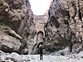
- Ferdows Hole-in-the-Rock
- Ferdows Hot Spring
- Ghal'eh Paeen-Shahr
- Jameh Mosque of Ferdows
- Kurit Dam
- Kushk Complex
- Qanats of Baladeh Ferdows
- Nehbandan Citadel
- Polond Desert
Learning and Education
South Khorasan has several places for higher education, where students can go to college and university. These include:
- University of Birjand
- Birjand University of Medical Sciences
- Islamic Azad University of Birjand
- Islamic Azad University of Ferdows
- Birjand University of Technology
- Payame Noor University
- University of Applied Science and Technology (south khorasan branch)
Images for kids
-
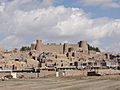
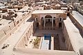
Birjand Castle
-
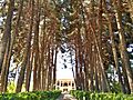
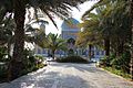
Akbarieh Garden in Birjand
-
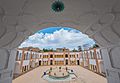
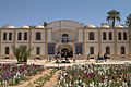
Shokatiyeh School in Birjand
-
Kolah Farangi Arg in Birjand
-
Mostofi House in Boshruyeh
-
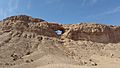
The Hole-in-the-Rock in Ferdows
-
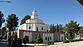
Golshan Garden in Tabas
-
A view of Tabas
-
Shah Abbasi Arch in Tabas
-
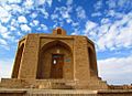
Ebn-e Hesam Khoosfi's Tomb near Khusf


See also
 In Spanish: Provincia de Jorasán del Sur para niños
