Irissarry facts for kids
Quick facts for kids
Irissarry
Irisarri
|
||
|---|---|---|
 |
||
|
||
| Country | France | |
| Region | Nouvelle-Aquitaine | |
| Department | Pyrénées-Atlantiques | |
| Arrondissement | Bayonne | |
| Canton | Pays de Bidache, Amikuze et Ostibarre | |
| Intercommunality | Pays Basque | |
| Area
1
|
26.39 km2 (10.19 sq mi) | |
| Population
(Jan. 2019)
|
912 | |
| • Density | 34.559/km2 (89.51/sq mi) | |
| Time zone | UTC+01:00 (CET) | |
| • Summer (DST) | UTC+02:00 (CEST) | |
| INSEE/Postal code |
64273 /64780
|
|
| Elevation | 149–839 m (489–2,753 ft) (avg. 225 m or 738 ft) |
|
| 1 French Land Register data, which excludes lakes, ponds, glaciers > 1 km2 (0.386 sq mi or 247 acres) and river estuaries. | ||
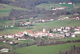
Irissarry is a small town, also known as a commune, located in the southwestern part of France. It is part of the Pyrénées-Atlantiques département, which is like a county or administrative area in France.
Contents
Discovering Irissarry
Irissarry is a charming commune nestled in the beautiful Pyrénées-Atlantiques region. This area is known for its stunning landscapes and rich culture. The commune is part of what is historically known as Lower Navarre, a region with deep roots in Basque history.
What is a Commune?
In France, a commune is the smallest administrative division. Think of it as a local area with its own government, similar to a city or town. Each commune has a mayor and a local council that makes decisions for the people living there.
Irissarry's Local Government
The mayor of Irissarry is Xavier Lacoste. He was elected for the term from 2020 to 2026. The mayor and the local council work together to manage the commune's daily life. This includes things like local services and community projects.
Location and Geography
Irissarry is situated in the Bayonne arrondissement and the Pays de Bidache, Amikuze et Ostibarre canton. These are other ways France divides its regions for administrative purposes.
The commune is located at coordinates 43.2581° N latitude and 1.2325° W longitude. Its elevation, or height above sea level, varies. The lowest point is 149 meters (about 489 feet), and the highest point reaches 839 meters (about 2,753 feet). The average elevation is around 225 meters (about 738 feet).
Population and Area
As of January 2019, Irissarry had a population of 912 people. The commune covers an area of 26.39 square kilometers (about 10.19 square miles). This makes it a relatively small commune in terms of both population and land size.
See also
 In Spanish: Irissarry para niños


