Ironside, Oregon facts for kids
Quick facts for kids
Ironside, Oregon
|
|
|---|---|

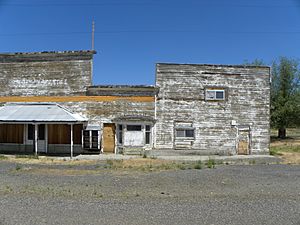
Abandoned building in Ironside
|
|
| Country | United States |
| State | Oregon |
| County | Malheur |
| Elevation | 3,783 ft (1,153 m) |
| Time zone | UTC−07:00 (Mountain (MST)) |
| • Summer (DST) | UTC−06:00 (MST) |
| ZIP Code |
97908
|
| Area code(s) | 541 |
| GNIS feature ID | 1136412 |
| Coordinates and elevation from Geographic Names Information System | |
Ironside is a small, quiet place in Malheur County, Oregon, in the United States. It's called an "unincorporated community," which means it doesn't have its own local government like a city or town. Instead, it's managed by the county. Ironside is about 46 miles (74 kilometers) northwest of a town called Vale. You can find it along U.S. Route 26, a main road. Even though it's small, Ironside has its own post office with the ZIP Code 97908, so people there can send and receive mail!
What's the Weather Like?
Ironside has a type of weather called a semi-arid climate. This means it's usually quite dry there. It doesn't get a lot of rain or snow throughout the year.
How We Know the Climate
Scientists use something called the Köppen Climate Classification system to describe climates around the world. For Ironside, this system labels its climate as "BSk." This "BSk" code tells us that it's a dry place, but not as dry as a desert. It often has hot summers and cold winters.
 | Kyle Baker |
 | Joseph Yoakum |
 | Laura Wheeler Waring |
 | Henry Ossawa Tanner |


