
Isiboro Sécure National Park and Indigenous Territory facts for kids
Quick facts for kids Isiboro Sécure National Park and Indigenous Territory |
|
|---|---|
|
IUCN Category II (National Park)
|
|

A man walks through the Isiboro Sécure park near the Sécure River
|
|

Isiboro Sécure is Protected Area 3 on this map.
|
|
| Location | Bolivia Beni Department, Cochabamba Department |
| Nearest city | Villa Tunari and San Ignacio de Moxos |
| Area | 1,372,180 ha |
| Established | November 22, 1965; Recognized as indigenous territory, September 24, 1990 |
| Governing body | Servicio Nacional de Áreas Protegidas (SERNAP) |
The Isiboro Sécure National Park and Indigenous Territory (often called TIPNIS) is a special protected area in Bolivia. It's located between the Cochabamba Department and the Beni Department. This huge area helps protect a part of the Bolivian Yungas ecoregion, which is a unique natural environment.
Many indigenous people live here, including the Tsimané, Yuracaré, and Mojeño-Trinitario groups. They have lived in this area for a very long time.
Contents
Why Is Isiboro Sécure Important?
This area was first made a National Park on November 22, 1965. Later, on September 24, 1990, it was also recognized as an indigenous territory. This happened after local native peoples marched and asked for their land rights to be protected.
Indigenous groups living in TIPNIS formed an organization called the Subcentral Indígena del TIPNIS (Subcentral TIPNIS) in 1988. This group helps manage and protect their land. In 2009, they officially received ownership of a large part of the park, about 1,091,656 hectares.

What Kinds of Nature Are in TIPNIS?
TIPNIS is home to four main types of natural environments:
- Flooded savannas: These are grassy plains that often get covered in water, similar to the Pantanal in other parts of South America.
- Sub-Andean Amazonian forest: Forests found on the lower slopes of the Andes mountains, leading into the Amazon.
- Pre-Andean Amazonian forest: Forests just before the Andes mountains, also part of the Amazon region.
- Bolivian-Peruvian Yungas: A unique type of forest found on the eastern slopes of the Andes, known for its cloud forests.
What Animals Live in TIPNIS?
This park is incredibly rich in wildlife! It's a home for many different species.
- Mammals: Over 218 different kinds of mammals.
- Birds: A huge number of birds, with 992 known species.
- Amphibians: 157 types of amphibians, like frogs and salamanders.
- Reptiles: 131 different kinds of reptiles, such as snakes and lizards.
Who Lives in TIPNIS?
TIPNIS is the ancestral home for three main indigenous groups. In 2001, about 12,388 indigenous people lived there in 64 communities.
- 1,809 people from the Yuracaré group.
- 4,228 people from the Trinitario-Mojeño group.
- 6,351 people from the Chimane group.
In some parts of the park, especially in the south, other families have moved in. These families are mostly farmers.
Exploring the Geography of TIPNIS
Rivers and Waterways
The park is part of the Mamoré River system, which flows into the huge Amazon Basin. The Sécure River and the Isiboro River are two very important rivers that flow through TIPNIS. The Sécure is in the north, and the Isiboro is in the south. The Ichoa River also flows through the middle of the park.
These rivers are like highways for people and animals in the park. Visitors often use them to travel and see the park's beauty. Many animals live in and around these rivers, including the special pink river dolphins!
Laguna Bolivia: A Wildlife Hotspot
Laguna Bolivia is a great place to see wildlife. You can reach it by boat during the rainy season, or by walking or riding a horse from nearby communities. It's a wonderful spot for observing the park's amazing animals.
What Challenges Does TIPNIS Face?
Protecting the Forests from Deforestation
One big challenge for TIPNIS is deforestation, which is when forests are cut down. This mostly happens in the southern part of the park where more people have moved in for farming. Experts worry that if this continues, a large part of the park's forests could be lost by 2030.
The Proposed Highway Project
For many years, there have been plans to build a highway right through the middle of TIPNIS. This road would connect the Cochabamba and Beni departments.
Many indigenous groups and environmentalists are against building the highway through the park. They worry it would cause a lot more deforestation and harm the unique environment and the people living there. They say that roads often lead to more trees being cut down.
In 2011, indigenous groups organized a big march from Villa Tunari to La Paz to protest the highway. This led to a law being passed that declared TIPNIS an "intangible zone," meaning no highways could be built through it. However, later on, new laws were passed that allowed for a "consultation process" about the road. In 2017, another law was passed that removed the special protections, opening the park to possible road construction and other projects. This is an ongoing discussion about how to balance development with protecting this important natural and cultural area.
Oil Exploration in the Park
Another challenge is that some areas within TIPNIS have been given as concessions for oil and gas exploration. This means companies might look for oil and gas there. Environmental groups are concerned that oil exploration and drilling could seriously damage the rivers and ecosystems of TIPNIS.
Images for kids
-
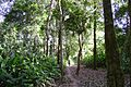
A man walks through the Isiboro Sécure park near the Sécure River
-
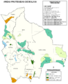
Isiboro Sécure is Protected Area 3 on this map.
-

Macheteros, a typical dance of Beni, performed by local Moxos people in Isiboro Sécure National Park, 2004
See also
 In Spanish: Territorio indígena y parque nacional Isiboro-Sécure para niños
