Ismayilli District facts for kids
Quick facts for kids
Ismayilli District
|
|
|---|---|
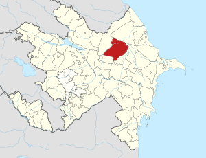
Map of Azerbaijan showing Ismayilli District
|
|
| Country | |
| Region | Mountainous Shirvan |
| Established | 24 November 1931 |
| Capital | Ismayilli |
| Settlements | 108 |
| Area | |
| • Total | 2,071 km2 (800 sq mi) |
| Population
(2020)
|
|
| • Total | 87,400 |
| • Density | 42.20/km2 (109.30/sq mi) |
| Time zone | UTC+4 (AZT) |
| Postal code |
3100
|
The Ismayilli District (Azerbaijani: İsmayıllı rayonu) is one of Azerbaijan's 66 districts. It is located in the northern part of the country. This district is part of the Mountainous Shirvan Economic Region. It shares borders with several other districts in Azerbaijan, and also with the Russian Republic of Dagestan. The main city and capital of the district is Ismayilli. In 2020, about 87,400 people lived here. People believe the district was named after Ismayil Baghiyev, a respected person who helped his community.
Contents
History of Ismayilli District
The Ismayilli district was officially created on November 21, 1931. Before this, different parts of the area belonged to other provinces like Goychay, Shamakhy, and Sheki.
Long ago, around the 4th century B.C., this area was part of an ancient state called Albania. A dynasty called Sasanies even had their own kingdom here. Famous Albanian rulers like Djavanshir (who lived from 616 to 681) were from this region. Djavanshir was a very important ruler from 638 to 670. You can still see the ruins of a tower he built near the Aghchay river, about 4 kilometers from Talystan village. It's known as the Djavanshir tower.
Many places in the Ismayilli district have a long and interesting history. Some of these include the settlements of Lahij and Basgal, and the villages of Ivanovka, Galadjyg, Talystan, and Diyarly. Lahij and Basgal are so special that they have been declared historical and cultural reserves.
Over the years, Ismayilli city has grown a lot. It was a village until 1959, then a settlement until 1967, and after that, it became a city. Today, efforts are being made to develop tourism in the district.
Geography and Nature
The Ismayilli district covers an area of about 2074 square kilometers. It borders Guba to the north and Shamakhy to the east. To the southeast, it borders Aghsu, and to the south, Kurdemir. Goychay is to the southwest, and Gabala is to the west.
The district has one main city, two settlements, and 106 villages. These areas are managed by local government groups.
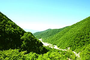
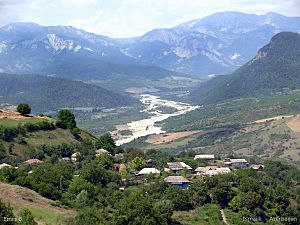
Most of the land here is mountainous. The height of the land ranges from 200 meters to 3629 meters above sea level. The highest point is called Babadagh. Several rivers flow through the district, including Goychay, Gyrdyman, and Akhokh. There are also artificial ponds like Yekekhana and Ashygbayram.
About 667.99 square kilometers of the district are covered by forests. The Ismayilli State Reserve is located here, protecting the natural environment. A part of the district is also included in the larger Shahdagh National Park.
Ismayilli is known for its beautiful nature. The forests are filled with different types of trees like oak, hornbeam, beech, and birch. You can also find many animals here, such as elk, mountain goats, deer, bears, wild boars, lynx, foxes, and wolves. There are also many birds like pheasants, partridges, and eagles.
People and Population
As of January 1, 2018, the population of Ismayilli district was about 86,100 people. The majority of the people living here are Azerbaijanis. Other groups include Tats, Armenians, Russians, and Lezgians.
Population Growth Over Time
The population of the Ismayilli district has been growing steadily. In 2000, there were about 73,000 people. By 2018, this number had increased by 13,100 people. Here's a look at how the population has changed:
| 2000 | 2001 | 2002 | 2003 | 2004 | 2005 | 2006 | 2007 | 2008 | 2009 | 2010 | 2011 | 2012 | 2013 | 2014 | 2015 | 2016 | 2017 | 2018 | 2019 | 2020 | 2021 | |
|---|---|---|---|---|---|---|---|---|---|---|---|---|---|---|---|---|---|---|---|---|---|---|
| Ismayilli region | 73,0 | 73,6 | 74,2 | 74,9 | 75,6 | 76,4 | 77,1 | 77,8 | 78,6 | 79,2 | 80,0 | 80,9 | 81,7 | 82,4 | 83,1 | 84,0 | 84,9 | 85,5 | 86,1 | 86,7 | 87,4 | 87,9 |
| Urban population | 15,4 | 15,6 | 15,8 | 16,0 | 16,3 | 16,5 | 16,7 | 16,9 | 17,1 | 17,3 | 17,4 | 17,6 | 17,7 | 26,7 | 26,9 | 27,2 | 27,6 | 27,8 | 27,9 | 28,1 | 28,4 | 28,6 |
| Rural population | 57,6 | 58,0 | 58,4 | 58,9 | 59,3 | 59,9 | 60,4 | 60,9 | 61,5 | 61,9 | 62,6 | 63,3 | 64,0 | 55,7 | 56,2 | 56,8 | 57,3 | 57,7 | 58,2 | 58,6 | 59,0 | 59,3 |
Languages Spoken
In the Ismayilli district, people speak several languages:
- Azerbaijani
- Tati
- Lezgian
- Russian
Local Media
The district has its own local newspaper and radio station.
The newspaper is called Girdyman. It started in 2002 and is published two or three times a month. It shares news and information with the community. Before 2002, the local newspaper had different names, like Yeni Ismayilly and Zehmetkesh.
The district's radio station began broadcasting on February 10, 1993. It provides daily news, fun programs, and shows for children. It also shares ads and announcements. The radio station broadcasts for thirty minutes each day, except on Saturdays and Sundays.
See also
 In Spanish: Raión de Ismailli para niños
 | James Van Der Zee |
 | Alma Thomas |
 | Ellis Wilson |
 | Margaret Taylor-Burroughs |


