
Israel National Trail facts for kids
Quick facts for kids Israel National Trail |
|
|---|---|

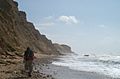
Hikers on the Israel National Trail
|
|
| Length | 1,025 kilometres (636.9 mi) |
| Location | Israel |
| Established | 1995 |
| Trailheads | North: Dan, South: Eilat |
| Use | Hiking |
| Season | Early spring |
| Months | November to May |
| Website | http://www.israeltrail.net/ |
The Israel National Trail is a super long hiking path in Israel. It opened in 1995. This amazing trail goes all the way across the country!
It starts way up north in a place called Dan, close to the border with Lebanon. Then it stretches all the way down south to Eilat, which is on the Red Sea. That's about 1,015 km (631 mi) long!
Look for its special marks: white, blue, and orange stripes. Most people take about 45 to 60 days to walk the whole trail. National Geographic magazine even called it one of the 20 most "epic trails" in the world!
They said it shows off huge biblical landscapes and the daily lives of people in modern Israel. Since 2016, you can even explore parts of the trail on Google Street View!
Contents
Exploring the Trail's Sections
The Israel National Trail is very long. Because of this, many people choose to walk only a part of it. The trail's official website divides the whole route into 11 smaller sections. This makes it easier for hikers to plan shorter trips.
Northern Israel Sections
The first few sections of the trail are in the northern part of Israel. This area is known for its green hills and streams.
- Naftali Ridge and Ramim Cliffs: This part is in the Upper Galilee region. You can see tall cliffs and beautiful views.
- Kadesh Ili Stream and Yesha Fortress: Also in the Upper Galilee, this section includes a stream and the historic Yesha fortress.
- Meron Stream to Ein Zeved: This path goes from the Meron stream's parking lot to a spring called Ein Zeved and the old Shema ruins. It's still in the Upper Galilee.
- Mount Tabor: This section takes you to Mount Tabor, a famous mountain in the Lower Galilee.
- Tzippori Stream: Another part in the Lower Galilee, following the Tzippori stream.
- Ma'apilim / Nakhash Stream: This section is near Mount Carmel.
Central and Southern Israel Sections
As you go further south, the landscape changes. You'll see mountains and then the desert.
- Shayarot Range: This part is in the Judean Mountains.
- Yatir Ruins to Dragot Quarry: This section takes you through interesting ruins and old quarries.
Negev Desert Sections
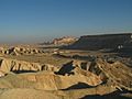
The last few sections of the trail are in the Negev Desert. This is a dry, rocky area with unique views.
- Mitzpe Ramon and Ramon Crater: This part goes through Mitzpe Ramon and the amazing Ramon Crater, which is a huge natural crater.
- Kisuy Stream and Ovda Valley: You'll find the Kisuy stream and the wide Ovda Valley in this desert section.
- Shkhoret Stream: The very last part of the trail is the Shkhoret stream, located in the Eilat Mountains, close to the end of the trail.
Images for kids
-
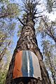
Israel Trail marker on a tree
-
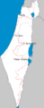
Route of Israel National Trail
-
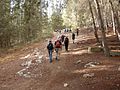
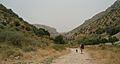
Hikers on Israel Trail
-
Sand Mountains of the Negev in southern Israel
-
Coast of Mediterranean
-
Eastern part of Dishon Stream
-
Elijah's Chair on Mount Meron


See also
 In Spanish: Sendero nacional de Israel para niños
