Itaquaquecetuba facts for kids
Quick facts for kids
Itaquaquecetuba
|
|||
|---|---|---|---|
|
Municipality
|
|||
| Municipality of Itaquaquecetuba | |||

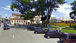
The square Padre João Álvares, in the center of the municipality. In the background, the first church of Itaquaquecetuba can be seen.
|
|||
|
|||
| Nickname(s):
Itaquá
|
|||

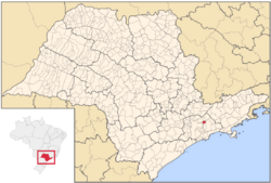
Location of Itaquaquecetuba
|
|||
| Country | |||
| Region | Southeast | ||
| State | |||
| Area | |||
| • Total | 82.62 km2 (31.90 sq mi) | ||
| Elevation | 790 m (2,590 ft) | ||
| Population
(2020)
|
|||
| • Total | 375,011 | ||
| • Density | 4,538.99/km2 (11,755.9/sq mi) | ||
| Time zone | UTC-3 (UTC-3) | ||
| • Summer (DST) | UTC-2 (UTC-2) | ||
| HDI (2010) | 0.714 – high | ||
Itaquaquecetuba, often called Itaquá, is a city in the state of São Paulo, Brazil. It is part of the large Metropolitan Region of São Paulo. About 375,011 people lived there in 2020. The city covers an area of about 82.62 square kilometers and is 790 meters high.
Jesuit priests, led by Father Joseph of Anchieta, founded Itaquaquecetuba between 1560 and 1563. They started a small settlement near the Tietê River to teach local people. For a long time, the city did not grow much. By the early 1900s, it was almost empty.
In 1958, Itaquaquecetuba became its own municipality, separate from Mogi das Cruzes. The first Mayor, Victorio Eugenio Deliberato, worked hard to bring industries to the city. This helped Itaquaquecetuba grow a lot in the years that followed. Today, Itaquaquecetuba is known as one of the top 10 Brazilian cities that have made big progress in reducing inequality. It also has the second-best economy in its region.
Contents
History of Itaquaquecetuba
The city of Itaquaquecetuba was one of twelve villages started by the Jesuit priest José de Anchieta. He spent a long time in Brazil. On September 7, 1560, the president of the province, Bernardo José Pinto Gavião Peixoto, officially named it the village of Nossa Senhora da Ajuda. It was set up along the Tietê River to teach the local Guaianases people.
What Does "Itaquaquecetuba" Mean?
The name "Itaquaquecetuba" comes from an old Tupi word, takwakisé-tube. This word means "place of abundant bamboo sharp as knives."
Getting Around Itaquaquecetuba
Public Transportation
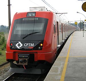
The city has a train system called Line 12 of CPTM. There are three train stations in Itaquaquecetuba: Engenheiro Manoel, Aracaré, and Itaquaquecetuba.
Local buses are run by Expresso Planalto. You can also take intercity buses to nearby cities like Poá, Mogi das Cruzes, Guarulhos, Arujá, Santa Isabel, Ferraz de Vasconcelos, Suzano, and São Paulo. Many bus companies operate these routes.
Main Roads and Highways
Itaquaquecetuba is connected by four important highways:
- SP-56 Alberto Hinoto Highway
- SP-66 João Afonso de Souza Castellano Highway
- SP-70 Ayrton Senna Highway
- SP-21 Mário Covas Beltway
Geography and Climate
City Climate
The climate in Itaquaquecetuba, like the rest of the Metropolitan Region of São Paulo, is Subtropical. This means that summers are usually a bit hot and rainy.
Learning and Education
Colleges and Universities
Itaquaquecetuba has several places for higher education:
- University of Guarulhos
- Technical School of Itaquaquecetuba - ETEC
- State Technological College of Itaquaquecetuba - FATEC
- Federal Institute of Education, Science and Technology of São Paulo - IFSP
Famous People from Itaquaquecetuba
- Cafu, a famous former football (soccer) player.
- Bento Hinoto, the guitarist for the band Mamonas Assassinas.
See also
 In Spanish: Itaquaquecetuba para niños
 | Georgia Louise Harris Brown |
 | Julian Abele |
 | Norma Merrick Sklarek |
 | William Sidney Pittman |


