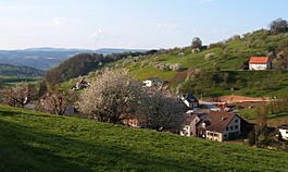
Ittenthal facts for kids
Quick facts for kids
Ittenthal
|
||
|---|---|---|
 |
||
|
||
| Country | Switzerland | |
| Canton | Aargau | |
| District | Laufenburg | |
| Area | ||
| • Total | 3.89 km2 (1.50 sq mi) | |
| Elevation | 404 m (1,325 ft) | |
| Population
(December 2006)
|
||
| • Total | 201 | |
| • Density | 51.67/km2 (133.8/sq mi) | |
| Postal code |
5083
|
|
| Surrounded by | Frick, Hornussen, Kaisten, Sulz | |
Ittenthal was once a small town in Switzerland. In Switzerland, small towns are often called 'municipalities'. Ittenthal was located in a part of Switzerland known as the canton of Aargau. It was also part of the Laufenburg district.
On January 1, 2010, Ittenthal joined with a nearby town called Kaisten. This means Ittenthal is no longer a separate municipality. It is now part of Kaisten.
Where Was Ittenthal Located?
Ittenthal was found in the northern part of Switzerland. It was in the canton of Aargau. A canton is like a state or a large region in Switzerland. Within Aargau, Ittenthal was part of the Laufenburg district. A district is a smaller area within a canton.
Ittenthal was surrounded by other towns. These included Frick, Hornussen, Kaisten, and Sulz.
How Many People Lived in Ittenthal?
Over the years, the number of people living in Ittenthal changed. Here is a look at its population history:
| year | population |
|---|---|
| 1803 | 171 |
| 1850 | 265 |
| 1900 | 217 |
| 1950 | 221 |
| 2000 | 222 |
As you can see, the population grew in the first half of the 1800s. Then it went down a bit by 1900. In the later years, the number of people stayed quite steady, around 220.
Why Did Ittenthal Merge?
Towns sometimes merge for different reasons. When Ittenthal merged with Kaisten in 2010, it meant that the two towns became one larger municipality. This can happen to make local government more efficient. It can also help share resources and services better between communities. Now, the people who live in Ittenthal are part of the larger community of Kaisten.
 | Emma Amos |
 | Edward Mitchell Bannister |
 | Larry D. Alexander |
 | Ernie Barnes |


