Ivishak River facts for kids
Quick facts for kids Ivishak River |
|
|---|---|

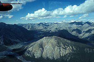
Upper Ivishak River Valley
|
|
|
Location of the mouth of the Ivishak River in Alaska
|
|
| Country | United States |
| State | Alaska |
| Borough | North Slope |
| Physical characteristics | |
| Main source | Philip Smith Mountains Brooks Range 5,258 ft (1,603 m) 68°34′25″N 147°16′43″W / 68.57361°N 147.27861°W |
| River mouth | Sagavanirktok River 55 miles (89 km) south of Prudhoe Bay 538 ft (164 m) 69°29′55″N 148°30′22″W / 69.49861°N 148.50611°W |
| Length | 95 mi (153 km) |
| Type: | Wild |
| Designated: | December 2, 1980 |
The Ivishak River is a river in Alaska, United States. It is about 95-mile (153 km) long. The Ivishak River flows into the Sagavanirktok River. It starts from melting glaciers high up in the Philip Smith Mountains. The river then flows through the northern part of the Arctic National Wildlife Refuge. Finally, it joins the Sagavanirktok River near Prudhoe Bay.
A Special River
A large part of the Ivishak River is very special. On December 2, 1980, about 80 miles (129 km) of the river was named a National Wild and Scenic River. This means it is protected by the government.
What "Wild and Scenic" Means
When a river is called "Wild and Scenic," it means it has amazing natural, cultural, or recreational value. These rivers are kept in their natural state. This helps protect their beauty and the wildlife that lives there.
Protected Sections
The protected parts of the Ivishak River include where it begins (its headwaters). It also includes a small stream that flows into it from Porcupine Lake. Most of the main river is also protected. All these special sections are found inside the Arctic National Wildlife Refuge. This refuge is a huge area set aside to protect nature.
 | Roy Wilkins |
 | John Lewis |
 | Linda Carol Brown |


