Sagavanirktok River facts for kids
Quick facts for kids Sagavanirktok River |
|
|---|---|

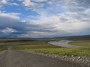
Along the Dalton Highway
|
|
|
Location of the mouth of the Sagavanirktok River in Alaska
|
|
| Native name | Saġvaaniqtuuq |
| Country | United States |
| State | Alaska |
| Borough | North Slope |
| Physical characteristics | |
| Main source | Between the Endicott and Philip Smith mountains Brooks Range 4,986 ft (1,520 m) 68°09′48″N 148°55′53″W / 68.16333°N 148.93139°W |
| River mouth | Slightly northeast of Prudhoe Bay Beaufort Sea 0 ft (0 m) 70°19′15″N 148°02′10″W / 70.32083°N 148.03611°W |
| Length | 180 mi (290 km) |
| Basin features | |
| Basin size | 5,750 sq mi (14,900 km2) |
The Sagavanirktok River, often called the Sag River, is a long river in Alaska, a state in the United States. Its name in the Iñupiaq language is Saġvaaniqtuuq. This river flows through the North Slope Borough, which is a very northern part of Alaska.
The Sag River is about 180 miles (290 km) long. It starts high up in the mountains and flows north. It eventually reaches the Beaufort Sea, which is part of the Arctic Ocean. The river's mouth is close to a place called Prudhoe Bay.
Contents
Where the Sag River Starts and Ends
The Sagavanirktok River begins in the Brooks Range. This is a large mountain range in northern Alaska. The river's source is between the Endicott and Philip Smith mountains. Here, it is about 4,986 feet (1,519 meters) above sea level.
From these mountains, the river flows north. It travels across the flat lands of the North Slope. Finally, it empties into the Beaufort Sea. This sea is located just northeast of Prudhoe Bay. At this point, the river is at sea level.
River's Neighbors: Pipeline and Highway
The Sagavanirktok River has two very important neighbors. These are the Trans-Alaska Pipeline System and the Dalton Highway. They run alongside the river for a long distance.
- The Trans-Alaska Pipeline System is a huge pipeline. It carries oil from the North Slope to ports further south in Alaska. It's a vital part of how oil gets from Alaska to other places.
- The Dalton Highway is a famous road. It runs next to the pipeline and the river. This highway is mostly used by trucks. They carry supplies to the oil fields in Prudhoe Bay.
Both the pipeline and the highway follow the river's path. They go from Atigun Pass all the way to Deadhorse. Deadhorse is a small community near Prudhoe Bay.
The River's Ancient Past
Long, long ago, the area around the Sagavanirktok River was shaped by ice. During a time called a glaciation, huge sheets of ice, known as glaciers, covered much of the land. This happened around the same time as a major ice age event in central North America. These glaciers carved out valleys and changed the landscape. This is why the river flows through the land the way it does today.
Wildlife Around the Sag River
The Sagavanirktok River and its surrounding areas are home to many animals. Even though it's a cold, northern region, lots of wildlife thrive here.
- Caribou often migrate through this area. They are large deer-like animals.
- Grizzly bears and polar bears can sometimes be seen. They hunt for food near the river.
- Many types of birds use the river for nesting and feeding. This is especially true during the warmer summer months.
- The river also has different kinds of fish. These fish are an important food source for other animals.
This makes the Sag River an important part of the Arctic ecosystem.
 | James Van Der Zee |
 | Alma Thomas |
 | Ellis Wilson |
 | Margaret Taylor-Burroughs |


