Jacó, Costa Rica facts for kids
Quick facts for kids
Jacó
|
|
|---|---|
|
District
|
|

Jacó Beach
|
|
| Country | |
| Province | Puntarenas |
| Canton | Garabito |
| Creation | 16 September 1965 |
| Area | |
| • Total | 141.11 km2 (54.48 sq mi) |
| Elevation | 7 m (23 ft) |
| Population
(2011)
|
|
| • Total | 11,685 |
| • Density | 82.808/km2 (214.471/sq mi) |
| Time zone | UTC−06:00 |
| Postal code |
61101
|
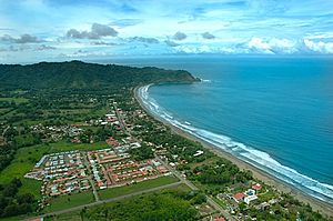
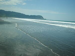
Jacó is a lively district in the Puntarenas area of Costa Rica. It is famous for its beautiful black sand beach. This beach is about 4 kilometers (2.5 miles) long. Many people love Jacó because it is a great spot for surfing.
Contents
Jacó's History
Jacó became its own district on September 16, 1965. Before that, it was part of the Puntarenas area.
Exploring Jacó's Geography
Jacó covers an area of about 141 square kilometers (54 square miles). It sits only 7 meters (23 feet) above sea level.
Jacó is surrounded by mountains. To the north, you'll find Herradura Bay. To the south is Playa Hermosa. Be careful not to mix it up with another beach called Playa Hermosa in Guanacaste!
Nearby Nature Parks
About 35 kilometers (22 miles) north of Jacó is the Carara National Park. This park is known for its amazing wildlife and thick rainforest. It is home to many wild scarlet macaws. These are beautiful red, yellow, and blue birds.
The Manuel Antonio National Park is also nearby. It is located about 75 kilometers (47 miles) south of Jacó.
How to Get to Jacó
Jacó is about 100 kilometers (62 miles) from San José, the capital city. The drive takes less than two hours. You can also get there from Juan Santamaría International Airport. This trip takes about one and a half hours.
Jacó's Climate
Since Jacó is right by the ocean, it is usually humid. The air often feels about 80% humid. In June, it can reach 90% humidity.
During the day, temperatures are usually between 24 and 32 degrees Celsius (75-90 degrees Fahrenheit). At night, it cools down a bit to 24-26 degrees Celsius (75-79 degrees Fahrenheit). In the dry season, away from the beach, it can get even hotter, sometimes reaching 35 degrees Celsius (95 degrees Fahrenheit) or more.
Jacó has two main seasons: a dry season and a wet season. The wet season is from August to early December. The dry season is from late December to early April. The other months have some rain, but it is not as regular.
Jacó's Population
| Historical population | |||
|---|---|---|---|
| Census | Pop. | %± | |
| 1973 | 2,959 | — | |
| 1984 | 3,144 | 6.3% | |
| 2000 | 6,371 | 102.6% | |
| 2011 | 11,685 | 83.4% | |
|
Instituto Nacional de Estadística y Censos |
|||
In 2011, about 11,685 people lived in Jacó.
Getting Around Jacó
Road Connections
Jacó is connected by an important road route.
Jacó's Economy and Tourism
Fun Activities in Jacó
Jacó's beach is a fantastic place for surfing. You can find many surfing schools there. Shops also rent and sell surfing gear. For more experienced surfers, Hermosa Beach is only five minutes away. It has bigger waves that are perfect for pros.
Jacó is not just about beaches and fun nightlife. It is also close to several national parks. Manuel Antonio National Park is about an hour's drive south.
There are many exciting tours you can take from Jacó. You can go on ATV rides or horseback riding tours. You can also enjoy snorkeling trips to Tortuga Island. Hiking and ziplining are popular activities too!
See also
 In Spanish: Jacó para niños
 | Shirley Ann Jackson |
 | Garett Morgan |
 | J. Ernest Wilkins Jr. |
 | Elijah McCoy |


