
Jacobswoude facts for kids
Quick facts for kids
Jacobswoude
|
|||
|---|---|---|---|
|
Municipality
|
|||
|
|||
 |
|||
| Country | Netherlands | ||
| Province | South Holland | ||
| Municipality | Kaag en Braassem | ||
| Area
(2006)
|
|||
| • Total | 41.37 km2 (15.97 sq mi) | ||
| • Land | 36.50 km2 (14.09 sq mi) | ||
| • Water | 4.87 km2 (1.88 sq mi) | ||
| Population
(1 January 2007)
|
|||
| • Total | 10,685 | ||
| • Density | 293/km2 (760/sq mi) | ||
| Source: CBS, Statline. | |||
| Time zone | UTC+1 (CET) | ||
| • Summer (DST) | UTC+2 (CEST) | ||
| Website | www.jacobswoude-zh.nl/ | ||


Jacobswoude (pronounced like YAH-kops-vow-duh) was a municipality, which is like a small local government area, in the western part of the Netherlands. It was located in the province of South Holland. Today, Jacobswoude is part of a larger municipality called Kaag en Braassem.
Before it merged with another area, Jacobswoude covered about 41 square kilometers (about 16 square miles). A big part of this area, almost 5 square kilometers, was water. This water mainly came from two lakes: Braassemermeer and Wijde Aa. Jacobswoude included several smaller communities. These were Bilderdam, Hoogmade, Leimuiden, Rijnsaterwoude, and Woubrugge. All these places were located around the lakes. In 2004, about 10,692 people lived in Jacobswoude.
Contents
Where Was Jacobswoude Located?
Jacobswoude was in the middle of an area known as the Groene Hart, which means "Green Heart." This "Green Heart" is a less crowded central part of the Randstad. The Randstad is a very busy region in the Netherlands with many large cities.
People living in Jacobswoude often traveled to bigger cities for things they needed. These cities included Alphen aan den Rijn, Leiden, and Amsterdam. Many residents would travel daily to these larger cities for work.
The History of Jacobswoude
How Jacobswoude Was Formed
Jacobswoude was created on January 1, 1991. This happened when three smaller municipalities joined together. These were Leimuiden, Rijnsaterwoude, and Woubrugge.
When Jacobswoude Merged
On January 1, 2009, Jacobswoude merged again. This time, it joined with another municipality called Alkemade. Together, they formed the new municipality of Kaag en Braassem.
The Lost Village of Jacobswoude
The municipality of Jacobswoude was named after a village that no longer exists. This lost village was once located within the area that became the municipality. The first mention of this village dates back to the year 823. It is believed that a person named Lord Jacob van den Woude was given this land. He received it as a "fiefdom," which was a piece of land granted by a king or lord in exchange for loyalty and service. The grant came from Louis the Pious, who was an emperor.
Over time, the land around the village was dug up. This was done to get "peat," which is a type of soil made from decayed plants, used as fuel. By the mid-1700s, so much peat had been removed that Jacobswoude became an island. Because it was surrounded by water, the village started to decline. Its people eventually moved to the nearby village of Woubrugge. Today, only a monument marks the spot where the original village once stood.
Wireless Jacobswoude
There is a project called Wireless Jacobswoude. This project is building a "wireless community network." It started in Woubrugge and is connected to a similar network called Wireless Leiden. This means people in the community can access internet and other services wirelessly.
Images for kids
-
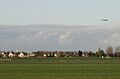
Leimuiden, a community that was part of Jacobswoude, seen from the south.
-
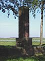
A monument marking the location of the lost village of Jacobswoude.
-
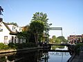
A bridge in Bilderdam, another community within the former Jacobswoude area.


