Jalapa, Indiana facts for kids
Quick facts for kids
Jalapa, Indiana
|
|
|---|---|

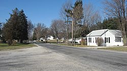
Houses on the Frances Slocum Trail at Jalapa
|
|

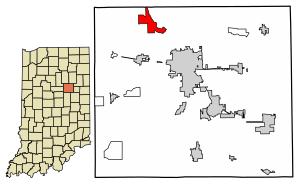
Location of Jalapa in Grant County, Indiana.
|
|
| Country | United States |
| State | Indiana |
| County | Grant |
| Township | Pleasant |
| Area | |
| • Total | 0.57 sq mi (1.48 km2) |
| • Land | 0.57 sq mi (1.48 km2) |
| • Water | 0.00 sq mi (0.00 km2) |
| Elevation | 820 ft (250 m) |
| Population
(2020)
|
|
| • Total | 182 |
| • Density | 318.18/sq mi (122.79/km2) |
| ZIP code |
46952
|
| FIPS code | 18-37674 |
| GNIS feature ID | 2583457 |
Jalapa is a small community in Indiana, United States. It is known as an unincorporated community, which means it doesn't have its own local government like a city or town. It is also a census-designated place (CDP). This means the U.S. Census Bureau defines it as a place for counting people.
Jalapa is located in Grant County, within Pleasant Township. In 2010, about 171 people lived there. A very important historical event, the Battle of the Mississinewa during the War of 1812, happened close by.
Contents
History of Jalapa: A Look Back
Jalapa has a short but interesting history. It started with a post office.
Early Post Office Days
The first post office in this area opened in 1848. It was called "Dallas." However, it only stayed open for about a year.
In 1849, the post office was renamed "Jalapa." It continued to serve the community for many years. The post office finally closed its doors in 1900.
How Jalapa Got Its Name
The community of Jalapa was named after a city in Mexico. That city is called Jalapa, or sometimes Xalapa-Enríquez. It is the capital of the Mexican state of Veracruz.
The Nearby Battle of Mississinewa
Not far from Jalapa is the site of the Battle of the Mississinewa. This battle was fought during the War of 1812. This war was between the United States and Great Britain, along with their Native American allies. The battle took place in December 1812. It was a significant event in the history of Indiana.
Geography: Where is Jalapa Located?
Jalapa is found in the northwestern part of Grant County. It sits on high ground.
Rivers and Waterways
The community is located just southwest of the Mississinewa River. This river flows towards the northwest. It eventually joins the Wabash River, which is a larger river in Indiana.
Distance to the County Seat
Jalapa is about 7 miles (11 kilometers) northwest of Marion. Marion is the largest city in Grant County. It is also the county seat, which means it's where the county government is located.
Size of the Community
According to the U.S. Census Bureau, the Jalapa census-designated place covers an area of about 0.57 square miles (1.48 square kilometers). All of this area is land; there are no large bodies of water within its boundaries.
Demographics: Who Lives in Jalapa?
Demographics is the study of populations. It helps us understand how many people live in a place and other facts about them.
Population Count
The 2020 census counted 182 people living in Jalapa. This number helps us see how the population has changed over time.
| Historical population | |||
|---|---|---|---|
| Census | Pop. | %± | |
| 2020 | 182 | — | |
| U.S. Decennial Census | |||
See also
 In Spanish: Jalapa (Indiana) para niños
 | Emma Amos |
 | Edward Mitchell Bannister |
 | Larry D. Alexander |
 | Ernie Barnes |


