Jean Quintin facts for kids
Jean Quintin (born January 20, 1500 – died April 9, 1561) was a French priest and writer. He was also a knight in a special group called the Order of St John. Quintin wrote an important book called Insulae Melitae Descriptio in 1536. This book was the first detailed description of the Maltese Islands. It also included the first printed map of these islands.
Who Was Jean Quintin?
Jean Quintin was born in a town called Autun in France. This was on January 20, 1500. He became a Roman Catholic priest. Later, he joined the Order of St John. This was a famous group of knights.
He became a chaplain for the French part of the Order. He also worked as a secretary for the Grand Master. The Grand Master was the leader of the Knights. Jean Quintin was also a professor at the University of Paris. He taught about church laws there.
Quintin's Writings
Jean Quintin wrote about many topics. These included geography, which is the study of Earth's features. He also wrote about cosmography, which is the study of the universe.
His most famous book is Insulae Melitae Descriptio. He published it in 1536. He wrote this book after visiting Malta in 1530. In 1540, he published another book in Paris. It was called Tractatus de ventis, et nautica buxula ventorum indice. This book was about winds and navigation.
Jean Quintin passed away on April 9, 1561. He was buried in Paris, France.
Insulae Melitae Descriptio Explained
Insulae Melitae Descriptio is a book about the Maltese Islands. It is eighteen pages long and was written in Latin. The book was finished on January 20, 1533. It was then published in Lyon in 1536.
This book is very important because it is the first detailed description of Malta. It also influenced many other books about the islands. Quintin wrote it based on what he saw himself. He also used old Roman writings and local stories. For example, he wrote about the story of St Paul's shipwreck. This story says that St Paul was shipwrecked in Malta.
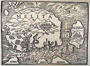
The book also had a woodcut map of Malta. This map is the oldest known printed map of the islands. The map is simple, but it shows the main features of Malta quite well. It is believed that Quintin himself might have made this map.
The text of Insulae Melitae Descriptio was printed seven times. Parts of it were later translated into Italian four times. In 1980, an English translation was published. It was done by Horatio C. R. Vella. This English version was part of a book called The Earliest Description of Malta (Lyons 1536) by Jean Quintin D'Autun.
 | Misty Copeland |
 | Raven Wilkinson |
 | Debra Austin |
 | Aesha Ash |


