Johns Creek Mountain facts for kids
Quick facts for kids Johns Creek Mountain |
|
|---|---|
| Location | Craig County Virginia, United States |
| Nearest town | New Castle, Virginia |
| Area | 6,323 acres (25.59 km2) |
| Administrator | U.S. Forest Service |
Johns Creek Mountain is a special wild area in western Virginia. It's part of the George Washington and Jefferson National Forests. A group called the Wilderness Society thinks this place is very important. They want to protect it from things like cutting down trees or building new roads. They even call it a "Mountain Treasure"!
This mountain ridge starts near New Castle, Virginia. It stretches about twelve miles southwest. The mountain is quite high, usually between 2,900 and 3,000 feet tall. You can explore the area using different trails. Johns Creek Mountain is also part of the Sinking Creek Valley Cluster.
Contents
Exploring Johns Creek Mountain
Where is Johns Creek Mountain?
Johns Creek Mountain is located in the Appalachian Mountains in southwestern Virginia. It's about two miles southwest of the town of New Castle, Virginia.
You can find roads around the area. Cumberland Gap Road (Virginia State Route 42) is on the southeast side. Johns Creek Road (Virginia Route 658) is on the northwest. Tub Run Road (Forest Road 257) also runs along the northwestern edge.
Trails and Paths
There are no official trails that the Forest Service maintains in this area. However, many paths lead up to the top of the mountain ridge. These paths are not kept up, but they can still be used to explore.
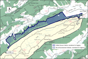
The map next to this text shows the boundaries of this wild area, as decided by the Wilderness Society. You can find more about the roads on National Geographic Map 788 (Covington, Alleghany Highlands). If you click on the coordinates at the top right of this page, you can find lots of information like topographic maps, aerial views, and even weather details for the area.
Besides the paths, you can also use old logging roads to explore. Many years ago, in the early 1900s, a lot of trees were cut down here. This left behind old logging roads. They are now becoming overgrown, but you can still walk on them. You can find these old roads and even old railroad paths by looking at historical maps from the United States Geological Survey (USGS). The Johns Creek Mountain wild area is shown on USGS maps called Looney, Potts Creek, and Craig Springs.
Nature and Landscape
What Grows Here?
This area is part of a larger region known for its forests. On the mountain ridge, you'll find many types of trees. These include white oak, northern red oak, chestnut oak, basswood, and hickory. Some of these trees are very old, like those you might find in an old-growth forest.
The Mountain and the Creek
Johns Creek Mountain is the main feature of this area. It's a long ridge, about 2,900 feet high, and forms the southeastern border.
Water from the area flows into Johns Creek. This creek then flows north to join Craig Creek near New Castle. For most of its path, Johns Creek is calm and smooth. But as it gets closer to New Castle, it drops through a deep gorge. Here, the water creates very difficult rapids (Class 4-5), which are a big challenge for people who like to paddle boats.
How the Forest Service Manages the Area
The Forest Service looks after these lands. They study different areas to see if they should be protected as "wilderness." When an area is called "wilderness," it gets a lot of protection from new buildings or development.
Some areas are called "inventoried roadless areas." This means they don't have roads and are protected from new road building. This helps keep the environment healthy. Johns Creek Mountain was not part of this "roadless area" review. This means it doesn't have the same protection from possible road construction or timber sales (when trees are cut down and sold).
Recreational Opportunities
The Forest Service also describes different parts of the forest by what kinds of fun activities you can do there. This helps visitors know what to expect.
- Much of the mountain ridge is called "Old Growth with Disturbance." This means it has old trees but has also been affected by past events.
- The eastern side has an area called "Ruffed Grouse Habitat." This is a good place for ruffed grouse, a type of bird.
- The western side is a "Mix of Successional Habitats," meaning it has different types of growing areas.
- There's also a "Scenic Corridor" next to Route 311, which is a beautiful area to see.
- A small piece of land near New Castle is called "Small Tract-Custodial." This land might be traded for other lands in the future.
Some parts of the area have had trees cut down recently. There might be more timber sales in the future in the "Ruffed Grouse Habitat" and "Mix of Successional Habitats" areas. There are also about 5.66 miles of Forest Service logging roads. These roads are not open for public cars or trucks.


