
Johnson Spur facts for kids


Johnson Spur (78°37′S 84°0′W / 78.617°S 84.000°W) is a rocky piece of land in Antarctica. It's like a small mountain ridge that sticks out. This interesting place is found on the eastern side of the Sentinel Range, which is part of the larger Ellsworth Mountains.
Johnson Spur is a very cold and icy place, just like the rest of Antarctica. It's important for scientists and mapmakers who study the geography of this frozen continent.
Contents
Johnson Spur: A Rocky Outcrop in Antarctica
Where is Johnson Spur Located?
Johnson Spur is located in a remote part of Antarctica. It's about 5.67 miles (9.12 km) south-southeast of a place called Taylor Spur. It's also 8.26 miles (13.29 km) southwest of Batil Spur and 8.65 miles (13.92 km) north-northwest of Long Peak.
This rocky spur marks the southeastern edge of the Doyran Heights. It has great views! To the east, it looks over the huge Rutford Ice Stream, which is like a slow-moving river of ice. To the west, it overlooks the Obelya Glacier.
How Was Johnson Spur Discovered and Named?
Johnson Spur was first mapped by the United States Geological Survey (USGS). This mapping happened between 1957 and 1959. Scientists used special surveys and air photos taken by the United States Navy to create the maps.
The name "Johnson Spur" was given by the Advisory Committee on Antarctic Names. They named it after William F. Johnson. He was a meteorologist, a scientist who studies weather, at the South Pole Station in 1957. Naming features after people who worked in Antarctica is a way to honor their contributions to exploring and understanding the continent.
Images for kids
-
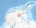
Location of Sentinel Range in Western Antarctica.
-
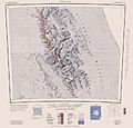
Sentinel Range map.
