
Sentinel Range facts for kids
Quick facts for kids Sentinel Range |
|
|---|---|

Sentinel Range
|
|
| Highest point | |
| Peak | Mount Vinson |
| Elevation | 4,892 m (16,050 ft) |
| Dimensions | |
| Length | 185 km (115 mi) NNW-SSE |
| Width | 48 km (30 mi) |
| Geography | |

Location of Sentinel Range in Western Antarctica
|
|
| Continent | Antarctica |
| State/Province | Ellsworth Land |
| Range coordinates | 78°10′S 85°30′W / 78.167°S 85.500°W |
| Parent range | Ellsworth Mountains |
| Borders on | Heritage Range |
The Sentinel Range is a very important mountain range in Antarctica. It's located north of the Minnesota Glacier and makes up the northern half of the Ellsworth Mountains. This mountain range stretches for about 185 kilometers (115 miles) from north-northwest to south-southeast. It is also quite wide, between 24 and 48 kilometers (15 to 30 miles).
Many of the peaks in the Sentinel Range are taller than 4,000 meters (13,123 feet). The most famous peak, Vinson Massif (which is 4,892 meters or 16,050 feet tall), is in the southern part of the range. It is the highest point on the entire continent of Antarctica!
The Sentinel Range includes a main ridge, where Vinson Massif is found. It also has many other distinct hills, ridges, and mountains on its eastern side. These include places like Petvar Heights, Doyran Heights, Veregava Ridge, Flowers Hills, Sullivan Heights, Barnes Ridge, Maglenik Heights, Probuda Ridge, Bangey Heights, Sostra Heights, and Gromshin Heights. The range is separated from the Bastien Range to the southwest by the Nimitz Glacier. To the south, it's separated from the Heritage Range by the lower Minnesota Glacier.
The Sentinel Range was first seen and photographed from the air on November 23, 1935. This was done by an explorer named Lincoln Ellsworth. He named it the "Sentinel Range" because it stood out like a guard or landmark in an otherwise flat, icy area. The first time people actually visited and partly mapped the range was in January 1958. This was during the Sentinel Mountains Traverse, led by Charles R. Bentley. Later, the entire range was mapped by the USGS. They used aerial photos taken by the U.S. Navy between 1958 and 1961.
-
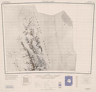
A map of the Northern Sentinel Range from the USGS.
-
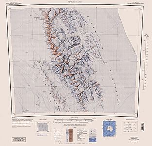
A map showing the central and southern Sentinel Range from the USGS.


Tallest Mountains and Peaks
The Sentinel Range is home to many impressive mountains. Here are some of the most important and tallest peaks in the range:
| Mountain | Metres | Feet | Coordinates |
|---|---|---|---|
| Mount Vinson | 4,892 | 16,050 | 78°31′31.74″S 85°37′1.73″W / 78.5254833°S 85.6171472°W |
| Mount Tyree | 4,852 | 15,919 | 78°24′42″S 85°51′43″W / 78.41167°S 85.86194°W |
| Clinch Peak | 4,841 | 15,883 | 78°32′08″S 85°30′45″W / 78.53556°S 85.51250°W |
| Corbet Peak | 4,822 | 15,820 | 78°31′31″S 85°32′50″W / 78.52528°S 85.54722°W |
| Schoening Peak | 4,743 | 15,561 | 78°31′36″S 85°27′57″W / 78.52667°S 85.46583°W |
| Hollister Peak | 4,729 | 15,515 | 78°32′43″S 85°35′19″W / 78.54528°S 85.58861°W |
| Príncipe de Asturias Peak | 4,680 | 15,354 | 78°32′50″S 85°42′32″W / 78.54722°S 85.70889°W |
| Mount Shinn | 4,660 | 15,289 | 78°27′S 85°46′W / 78.450°S 85.767°W |
| Fukushima Peak | 4,634 | 15,203 | 78°33′31″S 85°34′16″W / 78.55861°S 85.57111°W |
| Marts Peak | 4,551 | 14,931 | 78°32′18″S 85°24′07″W / 78.53833°S 85.40194°W |
| Branscomb Peak | 4,520 | 14,829 | 78°30′57″S 85°41′44″W / 78.51583°S 85.69556°W |
| Opalchenie Peak | 4,503.5 | 14,775 | 78°34′02″S 85°34′53″W / 78.56722°S 85.58139°W |
| Mount Rutford | 4,477 | 14,688 | 78°36′S 85°18′W / 78.600°S 85.300°W |
| Mount Craddock | 4,368 | 14,331 | 78°38′S 85°12′W / 78.633°S 85.200°W |
| Mount Anderson | 4,254 | 13,957 | 78°09′S 86°13′W / 78.150°S 86.217°W |
| Mount Bentley | 4,245 | 13,927 | 78°07′S 86°14′W / 78.117°S 86.233°W |
| Mount Ostenso | 4,180 | 13,714 | 78°18′S 86°11′W / 78.300°S 86.183°W |
| Peak 4111 | 4,160 | 13,648 | 78°13′S 86°08′W / 78.217°S 86.133°W |
| Mount Giovinetto | 4,090 | 13,419 | 78°16′S 86°10′W / 78.267°S 86.167°W |
| Evans Peak | 3,950 | 12,959 | 78°17′S 85°58′W / 78.283°S 85.967°W |
| Mount Goldthwait | 3,815 | 12,516 | 77°59′S 86°03′W / 77.983°S 86.050°W |
| Mount Davis | 3,800 | 12,467 | 78°06′S 86°15′W / 78.100°S 86.250°W |
| Mount Press | 3,760 | 12,336 | 78°09′18″S 85°59′45″W / 78.15500°S 85.99583°W |
| Mount Viets | 3,600 | 11,811 | 78°15′S 86°06′W / 78.250°S 86.100°W |
| Mount Todd | 3,600 | 11,811 | 78°05′39″S 85°52′39″W / 78.09417°S 85.87750°W |
| Mount Dalrymple | 3,600 | 11,811 | 77°56′S 86°03′W / 77.933°S 86.050°W |
| Mount Hale | 3,595 | 11,795 | 78°04′S 86°19′W / 78.067°S 86.317°W |
| Mount Tuck | 3,560 | 11,680 | 78°29′S 84°50′W / 78.483°S 84.833°W |
| Mount Slaughter | 3,444 | 11,299 | 78°37′S 85°38′W / 78.617°S 85.633°W |
| Knutzen Peak | 3,373 | 11,066 | 78°29′47″S 85°56′35″W / 78.49639°S 85.94306°W |
| Eyer Peak | 3,368 | 11,050 | 78°09′S 86°00′W / 78.150°S 86.000°W |
| Mount Atkinson | 3,300 | 10,827 | 78°39′S 85°29′W / 78.650°S 85.483°W |
| Mount Allen | 3,248 | 10,656 | 78°41′46″S 85°01′10″W / 78.69611°S 85.01944°W |
| Mount Alf | 3,200 | 10,499 | 77°55′S 86°07′W / 77.917°S 86.117°W |
| Mount Waldron | 3,100 | 10,171 | 78°27′S 84°53′W / 78.450°S 84.883°W |
| Mount Milton | 3,000 | 9,843 | 78°48′S 84°48′W / 78.800°S 84.800°W |
| Vanand Peak | 3,000 | 9,843 | 78°29′S 85°18′W / 78.483°S 85.300°W |
Maps
Maps of this region help explorers and scientists understand the landscape.
Geographical Features
The Sentinel Range has many interesting geographical features, including various heights, ridges, and glaciers. Here are some of the main ones:
Bangey Heights
This area is one of the distinct groups of heights on the east side of the Sentinel Range.
Doyran Heights
Another notable group of hills located in the Sentinel Range.
Flowers Hills
These hills are part of the eastern side of the Sentinel Range.
Gromshin Heights
These heights are found towards the northern part of the eastern side of the range.
Maglenik Heights
These are also among the distinct heights on the eastern side of the Sentinel Range.
Petvar Heights
Located in the southern part of the eastern side of the range, these heights are important features.
Sostra Heights
These heights are part of the eastern side of the Sentinel Range.
Sullivan Heights
These are a significant group of heights on the eastern side of the range.
Veregava Ridge
This ridge is another key geographical feature on the eastern side of the Sentinel Range.
Other Important Features
Besides the main heights and ridges, the Sentinel Range also includes many individual peaks, glaciers, and saddles (low points between peaks). These features are often named after explorers, scientists, or important events. They help to describe the detailed landscape of this vast icy region.
- Ahrida Peak
- Aster Glacier
- Branscomb Glacier
- Cairns Glacier
- Craddock Massif
- Della Pia Glacier
- Drama Glacier
- Gildea Glacier
- Hinkley Glacier
- Jacobsen Valley
- Minnesota Glacier
- Patton Glacier
- Roché Glacier
- Rumyana Glacier
- Saltzman Glacier
- Severinghaus Glacier
- Sowers Glacier
- Tulaczyk Glacier
- Vinson Massif
- Vinson Plateau
- Zapol Glacier
See also
 In Spanish: Cordillera Sentinel para niños
