
Marts Peak facts for kids


Marts Peak is a small, sharp mountain peak in Antarctica. It stands tall at 4,551 metres (14,931 ft) (about 14,931 feet) high. This icy peak is found on the eastern edge of the Vinson Plateau. The Vinson Plateau is part of the Sentinel Range, which is a big mountain range in the Ellsworth Mountains. Marts Peak looks over the Dater Glacier to its northeast and the Hammer Col to its south.
How Marts Peak Got Its Name
Marts Peak was named in 2006 by a group called the US-ACAN. This stands for the United States Advisory Committee on Antarctic Names. They named the peak after Brian Marts. Brian Marts was a brave explorer. He was part of the American Antarctic Mountaineering Expedition in 1966–67. This team made history by being the first to climb Mount Vinson. Mount Vinson is the highest mountain in all of Antarctica! Brian Marts and his team also climbed other tall mountains in the Sentinel Range.
Where is Marts Peak Located?
Marts Peak is located in a very cold and remote part of Antarctica. Its exact spot is at 78°32′18″S 85°24′07″W / 78.53833°S 85.40194°W. This peak is about 3.1 miles (5.0 km) (5 kilometers) east-southeast of Mount Vinson. It is also about 3.18 miles (5.12 km) (5.1 kilometers) northeast of Opalchenie Peak. Another nearby peak is Silverstein Peak, which is about 3.47 miles (5.58 km) (5.6 kilometers) east by north. These locations are based on maps made by the United States in 1961 and updated in 1988.
Images for kids
-
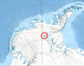
Location of Sentinel Range in Western Antarctica.
-
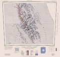
Central and southern Sentinel Range map.
