
Opalchenie Peak facts for kids
Quick facts for kids Opalchenie Peak |
|
|---|---|

Craddock Massif and Vinson Plateau in the left background, east view from above Rutford Ice Stream, West Antarctica
|
|
| Highest point | |
| Elevation | 4,503.5 m (14,775 ft) |
| Prominence | 63 m (207 ft) |
| Isolation | 0.8 km (0.50 mi) |
| Geography | |

Opalchenie Peak
Location in Antarctica
|
|
| Location | Ellsworth Mountains |
| Parent range | Sentinel Range |
| Climbing | |
| First ascent | Unclimbed |
| Easiest route | Rock/ice climb |
Opalchenie Peak (which means 'volunteer force' in Bulgarian) is a tall mountain peak in Antarctica. It rises to about 4,503.5 metres (14,775 ft) (that's over 14,700 feet!) and is covered in ice. You can find it at the very south end of the Vinson Plateau. This plateau is part of the Sentinel Range in the Ellsworth Mountains.
Even though it's very high, Opalchenie Peak doesn't stand out much from the mountains around it. It's only about 63 metres (207 ft) taller than the land connecting it to its "parent" mountain, Fukushima Peak. Fukushima Peak is even taller, at 4,634 metres (15,203 ft).
Parts of Opalchenie Peak's top and south sides are not covered in ice. Two parallel ridges go steeply down towards the southwest. The Donnellan Glacier flows between these ridges. Mount Slaughter is on the more southerly ridge. In November 1992, an American climber named Robert Anderson climbed the northerly ridge. This path was later used in 2003 to create a new way to climb Mount Vinson. Opalchenie Peak looks over the Vinson Plateau to the north, Craddock Massif to the southeast, and the upper Nimitz Glacier area to the southwest.
Why the Name Opalchenie Peak?
The peak is named after brave groups of volunteers from Bulgaria. These groups were called the "Opalchentsi" or "Bulgarian Volunteer Force." They fought in the Russo-Turkish War from 1877 to 1878. Another group, the Macedonian-Adrianopolitan Volunteer Corps, fought in the Balkan Wars from 1912 to 1913. The name 'opalchenie' is the Bulgarian word for 'volunteer force'.
Where is Opalchenie Peak Located?
Opalchenie Peak is located at 78°34′02″S 85°34′53″W / 78.56722°S 85.58139°W. It is about 4.73 kilometres (2.94 mi) southeast of Mount Vinson. It's also about 990 metres (1,080 yd) south of Fukushima Peak.
Here are some other distances to nearby peaks:
- 5.2 kilometres (3.2 mi) southwest of Schoening Peak
- 7.49 kilometres (4.65 mi) northwest of Mount Rutford
- 4.09 kilometres (2.54 mi) north by east of Mount Slaughter
- 7.41 kilometres (4.60 mi) east of Brichebor Peak
- 2.66 kilometres (1.65 mi) southeast of Silverstein Peak
The USGS created maps of this area in 1961 and updated them in 1988.
Images for kids
-
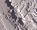
NASA image of Sentinel Range centred on Vinson Plateau and featuring Opalchenie Peak
-
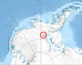
Location of Sentinel Range in West Antarctica
-
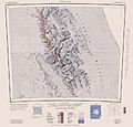
USGS map of central and southern Sentinel Range


