Kızılırmak River facts for kids
Quick facts for kids Kızılırmak |
|
|---|---|

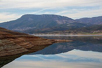
Kızılırmak in Samsun
|
|

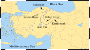
Map of the Kızılırmak watershed
|
|
| Other name(s) | Halys |
| Country | Turkey |
| Cities | Sivas, Kırşehir, Kırıkkale |
| Physical characteristics | |
| Main source | İmranlı, Sivas Province 2,000 m (6,600 ft) 39°48′N 38°18′E / 39.800°N 38.300°E |
| River mouth | Black Sea Bafra, Samsun Province 0 m (0 ft) 41°44′04″N 35°57′23″E / 41.73444°N 35.95639°E |
| Length | 1,355 km (842 mi) |
| Basin features | |
| Tributaries |
|
| Official name: Kizilirmak Delta | |
| Designated: | April 15, 1998 |
The Kızılırmak (which means "Red River" in Turkish) is the longest river that flows entirely within Turkey. It was once known as the Halys River. This important river helps create hydroelectric power (electricity from water). However, boats cannot travel on it.
Contents
The Kızılırmak River: Where Does It Flow?
The Kızılırmak River is very long, stretching for about 1,355 kilometers (842 miles). It starts in Eastern Anatolia, a region in Turkey, high up at about 2,000 meters (6,560 feet) above sea level.
The River's Journey to the Sea
From its source, the river first flows towards the west and southwest. Then, it makes a big curve, often called the "Halys bend." After this bend, it flows northwest, passing by Lake Tuz (a large salt lake).
Next, the Kızılırmak turns north and northeast. Along its journey, other rivers join it. The Delice River is one of its main branches. Later, the Devrez River and the Gökırmak (meaning "Sky River") also flow into the Kızılırmak.
Finally, the Kızılırmak forms a wide delta (a landform created by sediment deposits at a river's mouth). This delta is northwest of Samsun, where the river empties into the Black Sea.
The Kızılırmak's Role in History
The Kızılırmak River has been very important throughout history. Ancient civilizations used it as a natural boundary.
An Ancient Border: Hittites to Romans
The Hittites, an ancient people, called this river the Maraššantiya. For them, it marked the western edge of their main land, Hatti.
Later, the Halys River (as it was known then) served as a natural border in central Asia Minor (ancient Turkey). It separated powerful kingdoms and empires. For example, it was the border between the kingdom of Lydia and the Persian Empire.
A famous event, the Battle of the Eclipse, happened near this river on May 28, 585 BC. The river marked the border between Lydia and Media. Later, the Lydian king Croesus crossed the river to attack Cyrus the Great of Persia in 547 BC. Croesus lost, and Persia expanded its territory all the way to the Aegean Sea.
By the 1st century AD, the Roman Empire controlled this region. The Halys River became an "interior river" within the Roman province of Cappadocia. It no longer served as a major political border. A Roman governor even wrote that the river, once a border for kings, now flowed entirely under Roman rule.
How People Use the Kızılırmak Today
The Kızılırmak River is still very useful for people living in Turkey. Its water helps farmers grow crops like rice. Some areas also use the river to raise water buffalo.
Dams and Their Impact
There are several dams built on the Kızılırmak River. These include the Boyabat, Altınkaya, and Derbent dams. Dams are important because they help control the river's flow and generate electricity. However, they also reduce the amount of sediment (like sand and mud) that flows down to the river's delta. This can lead to the coastline slowly wearing away.
 | Emma Amos |
 | Edward Mitchell Bannister |
 | Larry D. Alexander |
 | Ernie Barnes |

