
Kabile Island facts for kids

Kabile Island from English Strait, with Hrabar Nunatak, Greenwich Island and Sharp Peak, Livingston Island in the background
|
|

Location of Kabile Island
|
|

Kabile Island
Location in Antarctica

Kabile Island
Location in Antarctic Peninsula
|
|
| Geography | |
|---|---|
| Location | Antarctica |
| Coordinates | 62°26′30″S 59°56′33″W / 62.44167°S 59.94250°W |
| Archipelago | South Shetland Islands |
| Area | 19 ha (47 acres) |
| Length | 0.7 km (0.43 mi) |
| Administration | |
| Administered under the Antarctic Treaty System | |
| Demographics | |
| Population | Uninhabited |
Kabile Island is a small island located in Antarctica. It stretches about 700 meters (2,300 feet) from north to south and is about 450 meters (1,476 feet) wide. This makes its total area about 19 hectares (47 acres).
The island is part of the South Shetland Islands. It lies just off the northern coast of Greenwich Island. Kabile Island is named after an ancient town called Kabile. This old town was in Thrace, a region near the modern country of Bulgaria.
Where is Kabile Island Located?
Kabile Island is found at 62°26′30″S 59°56′33″W / 62.44167°S 59.94250°W. It is situated close to several other points of interest in the area.
Nearby Landmarks
The island is about 950 meters (1,039 yards) east of Pavlikeni Point. It is also 1 kilometer (0.6 miles) north of Crutch Peaks. To the northwest, it is about 200 meters (219 yards) from Miletich Point. Another island, Ongley Island, is about 2.5 kilometers (1.6 miles) to the west-southwest.
Scientists and mapmakers have been studying and mapping this area for many years. Chilean mappers worked here in 1966. British mappers followed in 1968. More recently, Bulgarian teams created maps in 2009.
Images for kids
-
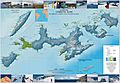
A topographic map showing Livingston Island, Greenwich Island, and nearby areas.

