Kaiapoi River facts for kids
Quick facts for kids Kaiapoi River |
|
|---|---|

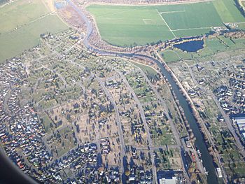
Kaiapoi River through Kaiapoi, with the Courtenay Stream on the top right
|
|
| Lua error in Module:Location_map at line 420: attempt to index field 'wikibase' (a nil value).
Location of the mouth within New Zealand
|
|
| Country | New Zealand |
| Physical characteristics | |
| River mouth | Waimakariri River |
| Length | 16 km (9.9 mi) |
| Basin features | |
| Basin size | 430 km2 (170 sq mi) |
The Kaiapoi River is a small but important river in the northern part of Canterbury, located on New Zealand's South Island. It was once known as the Cam River. This river flows into the much larger Waimakariri River where it meets the sea at its estuary. The Kaiapoi River is about 16 kilometers (10 miles) long. Its drainage area, which is the land where all the water flows into the river, covers about 430 square kilometers (166 square miles).
About the Kaiapoi River
The Kaiapoi River flows past several towns. These include Rangiora, Kaiapoi, and Woodend. These towns are built right on the river's banks.
What Flows Into the River?
The Kaiapoi River has several smaller rivers and streams that flow into it. These are called tributaries. One important tributary is also named the Cam River. In the late 1800s and early 1900s, this Cam River was used for carrying heavy loads. People would use it to transport logs and wool.
Many of the streams that join the Kaiapoi River are home to lots of fish. You can find large numbers of salmon and trout here. The Cam River, for example, was a very popular spot for fishing in the 1940s. Even today, it still has many trout living in its waters.
 | Kyle Baker |
 | Joseph Yoakum |
 | Laura Wheeler Waring |
 | Henry Ossawa Tanner |

