Kalat, Balochistan facts for kids
Quick facts for kids
Kalat
قلات
Qalāt
|
|
|---|---|
|
District Headquarter / City
|
|

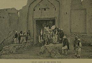
Outer wall of Kalat city
|
|
| Country | Pakistan |
| Region | Balochistan |
| District | Kalat |
| Government | |
| • Type | City |
| Area | |
| • Total | 489 km2 (189 sq mi) |
| Elevation | 2,007 m (6,585 ft) |
| Population
(2017)
|
|
| • Total | 36,796 |
| Time zone | UTC+5 (PST) |
| Area code(s) | +92844 |
Kalat or Qalat is a historic town in Pakistan. It is located in the Balochistan province. People also call it Kalat-e-Brahui or Kalat-e-Sewa.
Kalat is in the middle of the Balochistan province. It used to be the main city of the Kalat Khanate. A Khan is like a traditional ruler. Today, the Khan of Kalat is a special title. The current Khan is Mir Suleman Dawood Jan. His son, Prince Mohammed, is next in line.
Contents
Weather in Kalat
Kalat has a cold desert climate. This means it is very dry and can get quite cold. The average temperature in Kalat is about 14.1 degrees Celsius. Each year, it gets about 163 millimeters of rain.
June is the driest month, with only 1 millimeter of rain. January is the wettest month, with about 36 millimeters of rain. July is the warmest month, with an average temperature of 24.8 degrees Celsius. January is the coldest month, with an average of 3.4 degrees Celsius.
The coldest temperature ever recorded in Kalat was -17 degrees Celsius. This happened on January 20, 1978. The hottest temperature recorded was 38 degrees Celsius. This was on June 19, 1977.
| Climate data for Kalat | |||||||||||||
|---|---|---|---|---|---|---|---|---|---|---|---|---|---|
| Month | Jan | Feb | Mar | Apr | May | Jun | Jul | Aug | Sep | Oct | Nov | Dec | Year |
| Mean daily maximum °C (°F) | 10.3 (50.5) |
12.1 (53.8) |
17.1 (62.8) |
22.1 (71.8) |
27.4 (81.3) |
31.9 (89.4) |
32.6 (90.7) |
31.7 (89.1) |
28.6 (83.5) |
23.3 (73.9) |
17.5 (63.5) |
13.1 (55.6) |
22.3 (72.2) |
| Daily mean °C (°F) | 3.4 (38.1) |
5.3 (41.5) |
9.8 (49.6) |
14.3 (57.7) |
18.9 (66.0) |
22.7 (72.9) |
24.8 (76.6) |
23.4 (74.1) |
19.4 (66.9) |
13.8 (56.8) |
8.6 (47.5) |
4.9 (40.8) |
14.1 (57.4) |
| Mean daily minimum °C (°F) | −3.5 (25.7) |
−1.5 (29.3) |
2.6 (36.7) |
6.6 (43.9) |
10.5 (50.9) |
13.5 (56.3) |
17.0 (62.6) |
15.2 (59.4) |
10.3 (50.5) |
4.3 (39.7) |
−0.2 (31.6) |
−3.3 (26.1) |
6.0 (42.7) |
| Source: Climate-Data.org | |||||||||||||
People of Kalat
Most people in Kalat are Muslims, making up about 97 percent of the population. There is also a small group of Hindu people. Many of these Hindus are merchants who consider Kalat their home.
In 2017, the total population of Kalat was 36,796 people. Most of them were Muslims.
Kalat Kali Temple
There is a Hindu temple in Kalat. It is dedicated to the goddess Kali.
History of Kalat
The town of Kalat is very old. It is believed to have been named Qalat-e Sewa. This name comes from Sewa, a legendary hero of the Brahui people.
The Brahui-speaking tribes arrived in the Kalat area a long time ago. They came before the Balochi-speaking tribes. The Brahui people created a large kingdom in the 15th century. But this kingdom later became smaller.
The area was then ruled by the Mughal Empire for a short time. After that, the Brahui-speaking Khans of Kalat became powerful. They ruled from the 17th century until the British arrived in the 19th century. In 1876, a treaty was signed. This made Kalat part of the British Empire.
In 1947, when Pakistan became an independent country, the Khan of Kalat agreed to join Pakistan. In 1948, Kalat officially became part of Pakistan. The last Khan of Kalat was no longer in power by 1955. However, his family still uses the title today. The current Khan of Kalat is Mir Suleman Dawood Khan Ahmadzai.
Images for kids
See also
 In Spanish: Kalat para niños


