Kanlaon facts for kids
Quick facts for kids Mount Kanlaon |
|
|---|---|
| Kanlaon Volcano | |

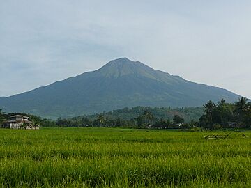
Kanlaon in 2009
|
|
| Highest point | |
| Elevation | 2,465 m (8,087 ft) |
| Prominence | 2,465 m (8,087 ft) |
| Listing |
|
| Geography | |
| Country | Philippines |
| Region |
|
| Provinces |
|
| City/municipality |
|
| Geology | |
| Mountain type | Stratovolcano |
| Volcanic belt | Negros Volcanic Belt |
| Last eruption | Ongoing |
Mount Kanlaon, also called Kanlaon Volcano, is an active volcano in the Philippines. It is the tallest mountain on Negros Island and the highest peak in the Visayas region, standing about 2,465 meters (8,087 feet) above sea level. This makes it one of the highest island peaks in the world.
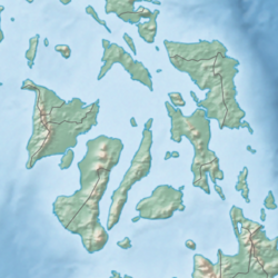
Mount Kanlaon is located between the provinces of Negros Occidental and Negros Oriental. It is about 30 kilometers (19 miles) southeast of Bacolod City. Kanlaon is one of the many active volcanoes in the Philippines, which are all part of the famous Pacific Ring of Fire.
Contents
What's in a Name? The Meaning of Kanlaon
The name "Kanlaon" means "place of Laon". Laon was a very important goddess in the beliefs of the Visayans before the Spanish arrived. She was believed to be the creator of things, and was also linked to farming and fairness. The word "Laon" itself means "the ancient one" in the Visayan language.
For a short time during the Spanish colonial period, the volcano was called Malaspina. This name was given after a Spanish explorer named Alejandro Malaspina.
Exploring Kanlaon's Geography and Geology
Mount Kanlaon reaches an elevation of about 2,465 meters (8,087 feet). Its base is about 30 kilometers (19 miles) wide. The volcano has many smaller cones and old craters around it. Just below the main peak, to the north, is the active Lugud crater. North of Lugud, there's a large basin called Margaja Valley. It has a small lake that sometimes dries up. The whole volcano area covers about 24,557 hectares (95 square miles).
Kanlaon also has three hot springs on its slopes: Mambukal Hot Springs, Bucalan Hot Spring, and Bungol Hot Spring. Nearby volcanoes include Mount Silay and Mount Mandalagan to the north.
Several cities and towns are located around the volcano. These include La Carlota, La Castellana, Murcia, and San Carlos in Negros Occidental. The city of Canlaon in Negros Oriental is also on the lower slopes of the volcano.
Kanlaon's Eruptions Over Time
Kanlaon is the most active volcano in the Visayas region. It has erupted more than 30 times since 1819. Most of its eruptions are phreatic, which means they are caused by steam and produce small to medium amounts of ash. This ash usually falls around the volcano. In 1902, there was a Strombolian eruption. This type of eruption shoots out glowing rocks, ash, and gas.
The Philippine Institute of Volcanology and Seismology (PHIVOLCS) constantly watches Kanlaon's activity. The Kanlaon Volcano Observatory is located in La Carlota City.
The 1996 Eruption
On August 10, 1996, 24 mountain climbers were on the volcano when it suddenly erupted. Sadly, some climbers, including British student Julian Green and Filipinos Jamrain Tragico and Neil Perez, lost their lives near the summit. Local authorities rescued 17 other climbers, including 10 Belgians and another British climber. One of the rescued climbers, Caroline Verlinde, said that the volcano suddenly shot out ash, stones, and hot gas. She saw her friends get hit by hot rocks.
Recent Volcanic Activity of Kanlaon
Volcanoes like Kanlaon are always being monitored for signs of activity. Here's a look at some of its recent events:
2001: Earthquake Swarms
In early 2001, PHIVOLCS noticed many small earthquakes around the volcano. These "earthquake clusters" suggested that the volcano's internal system might be waking up. PHIVOLCS warned that ash explosions could happen suddenly, so they advised people not to hike to the summit.
2002: Increased Activity
After more earthquakes from February to April, the alert level for Kanlaon was raised. On November 28, a small ash eruption occurred.
2003: Small Ash Plumes
On March 17, a gray cloud of ash was seen above Kanlaon. There were 46 small ash eruptions that sent plumes up to 100 meters (328 feet) high. By July, the activity returned to normal.
2005: Ashfall Events
On January 21, a quick steam-driven ash eruption happened, sending a plume 500 meters (1,640 feet) high. Fine ash fell on nearby areas. More ash emissions happened in March and April, with plumes reaching up to 1 kilometer (0.6 miles) high. Ashfall was reported in towns like La Castellana.
2006: Steam and Ash
Kanlaon became restless again on June 3, releasing steam and ash. The alert level was raised to 1. There were 23 ash eruptions until July 25. All of these were phreatic, meaning they were caused by steam, not fresh magma.
2008: Low-Frequency Earthquakes
On February 10, PHIVOLCS recorded 21 low-frequency volcanic earthquakes. This led to the alert level being raised to 1, meaning slight unrest. A 4-kilometer (2.5-mile) "Permanent Danger Zone" was set up around the volcano because sudden explosions could happen.
2009: More Earthquakes
From August 23 to September 1, 257 volcanic earthquakes were recorded. These earthquakes were mostly on the northwest side of the volcano, possibly showing movement deep inside. Despite this, the alert level stayed at 0.
2015: Steam-Driven Explosions
On November 23, Kanlaon had a small, steam-driven explosion. PHIVOLCS raised the alert level to 1. In December, there were two small ash eruptions, with plumes reaching up to 984 meters (3,281 feet) high. Light ashfall was reported in nearby villages.
2016: Booming Sounds and Fireballs
On March 29, Kanlaon erupted for 12 minutes, sending a plume 1,500 meters (4,921 feet) above the crater. People nearby heard a "booming sound," and some even saw "fireballs" coming from the crater, which caused a bush fire. The alert level was set to 1.
2020: Increased Unrest
On March 11, PHIVOLCS raised the alert level to 1 due to unusual activity since March 9, including 80 volcanic earthquakes. By June, activity continued with more earthquakes. PHIVOLCS reminded everyone to stay out of the 4-kilometer (2.5-mile) Permanent Danger Zone.
2024: Major Eruptions and Impact
On June 3, Kanlaon had an explosive eruption, sending a huge, glowing plume 5,000 meters (16,404 feet) into the sky. Hot ash and gas flowed down the volcano's slopes. Ashfall and a sulfur smell were reported in many communities, even as far as Bacolod City. Rains later caused mudflows called lahars.
Many people had to leave their homes in nearby towns like Canlaon, La Carlota, and La Castellana. Flights were cancelled at several airports. A "state of calamity" was declared in some areas, and farming lands were affected. On July 15, PHIVOLCS noted that the volcano was swelling, which could mean more magma was moving inside. In September, very high levels of sulfur dioxide gas were released, suggesting a possible larger eruption. On December 9, the alert level was raised to 3 after another explosive eruption. This eruption produced a large plume and pyroclastic flows, causing ashfall as far as Panay and Guimaras. Around 87,000 people were evacuated.
Mythology: The Spirit of Kanlaon
In the old beliefs of the Visayan peoples, Kanlaon was thought to be the home of a powerful female spirit named Laon. She was seen as the supreme creator deity for many Visayan groups. People would pray to her for good harvests. If she was unhappy, she might send locusts to destroy crops. It was specifically believed that she lived inside the Kanlaon volcano.
Hiking and Exploring Kanlaon
Mount Kanlaon is a popular place for mountain climbers. It is the main feature of the Mount Kanlaon Natural Park, which became a national park in 1934.
Hiking trails usually start in Barangay Guintubdan. Locals are working with European groups to use a special hiking marker system. This system uses colored signs to help hikers find their way, making the mountain more welcoming for tourists while protecting nature.
Trails & Hiking Markers System
In 2016 and 2017, several hiking trails were marked using this system. The trails are color-coded using the colors of the Philippine flag:
- Red Trail from Guintubdan to Buslugan Falls (marked in 2016)
- Yellow Trail from Guintubdan to Oro Falls (marked in 2016)
- Blue Trail from Guintubdan to Salas Park new Pavilion (marked in 2016)
- Red Trail from Guintubdan to Mt. Kanlaon Summit (marked in 2017)
- Adventure Trail and additional new trails (marked in 2017)
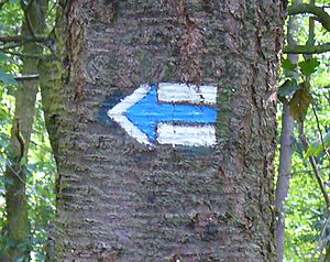
This system uses three bars, usually one color between two white bars. Different colors have different meanings:
- Red means the most difficult trails or trails to the summit.
- Blue means difficult trails.
- Yellow and Green mean easy or connecting trails.
These marks can be on wooden boards or metal plates. Basic trail markers are square, about 10x10 cm (4x4 inches). If the trail changes direction, there will be arrows of the same color.
See also
 In Spanish: Monte Canlaón para niños
- List of volcanoes in the Philippines
- List of active volcanoes in the Philippines
- List of protected areas of the Philippines
 | Toni Morrison |
 | Barack Obama |
 | Martin Luther King Jr. |
 | Ralph Bunche |


