
Kaponga facts for kids
Quick facts for kids
Kaponga
|
|
|---|---|
.jpg)
The Kaponga Logo
|
|
| Country | New Zealand |
| Region | Taranaki Region |
| Territorial authority | South Taranaki District |
| Ward |
|
| Community | Eltham-Kaponga Community |
| Electorates |
|
| Area | |
| • Total | 1.56 km2 (0.60 sq mi) |
| Population
(June 2023)
|
|
| • Total | 340 |
| • Density | 218/km2 (564/sq mi) |
Kaponga is a small town located in the southern part of the Taranaki region in New Zealand. It's often called "The Gateway to Dawson's Falls" because it's close to Mount Taranaki.
The town is found inland from places like Manaia and Eltham. It sits on the main road that connects Eltham to Ōpunake. Ōpunake is about 26 kilometers (16 miles) to the west, and Eltham is 13 kilometers (8 miles) to the east. Manaia is about 15 kilometers (9 miles) south of Kaponga.
Contents
Kaponga's History
Kaponga was first settled in 1882. It has strong ties to Switzerland because some of the first people to live here were from Switzerland. In fact, the Taranaki Swiss Club was started in 1952.
The town used to be much bigger, with many more shops than it has today. Now, there are only a few stores. Kaponga is also home to a very special place called Hollard Gardens, which is a garden of national importance.
Many businesses in and around Kaponga rely on the dairy industry, which is very important in the area. The community also has a South Taranaki District Council LibraryPlus. This place offers full library services and helps with council-related tasks, like registering a dog or asking about building permits. The LibraryPlus also has computers with free internet and Skype for everyone to use.
Who Lives in Kaponga?
Kaponga is considered a rural settlement by Statistics New Zealand. In 2018, about 309 people lived here. The town covers an area of 1.56 square kilometers (0.60 square miles).
The population of Kaponga has changed over the years:
- In 2006, there were 363 people.
- In 2013, the number dropped to 297.
- By 2018, it increased slightly to 309 people.
In 2018, there were 126 households in Kaponga. There were more males (171) than females (144). About 20% of the people were under 15 years old. Most people were between 30 and 64 years old.
Most people in Kaponga are of European background (81.6%). About 28.2% are Māori, and smaller numbers are from Pacific Islands or Asia. Many people (56.3%) said they had no religion, while 29.1% were Christian.
About half of the people aged 15 or older worked full-time. Some worked part-time, and a small number were unemployed.
Kaponga-Mangatoki Area
Kaponga is part of a larger area called Kaponga-Mangatoki. This area covers 172.81 square kilometers (66.72 square miles). In 2018, about 1,305 people lived in the Kaponga-Mangatoki area.
The population here also changed over time:
- In 2006, there were 1,371 people.
- In 2013, the number was 1,281.
- In 2018, it grew to 1,305 people.
In this wider area, the median age was 34.1 years. About 25.7% of the people were under 15 years old. Most people were European (88.5%), and 14.0% were Māori.
Education in Kaponga
Kaponga has two main schools for primary-aged students.
Kaponga School
Kaponga School teaches students from Year 1 to Year 8. It was first opened in 1891. In 2005, two other schools, Kapuni and Mahoe, closed down and joined with Kaponga School. As of 2023, the school has 110 students.
St Patrick's School
St Patrick's School is a Catholic school that also teaches students from Year 1 to Year 8. It began in 1921, with lessons first held in the local church. The school moved into its own building in February 1922. As of 2023, St Patrick's School has 40 students.
Both schools are coeducational, meaning they teach both boys and girls.
Sports: Association Football
The Kaponga Soccer Club was started in 1906. It is one of the oldest football clubs in the Taranaki region. The club has won the Taranaki Championship three times: in 1909, 1912, and 1924. In 1926, they won the Manaia Hibernian Society 7-a-side cup. After this, the club stopped playing for a while.
A new club called Egmont United was formed in 1929. This team included players from Kaponga, Auroa, Eltham, and Stratford. However, this club also stopped playing in 1931.
Images for kids
-
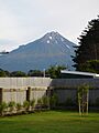
Mount Taranaki seen from a home in Kaponga

