Eltham, New Zealand facts for kids
Quick facts for kids
Eltham
|
|
|---|---|

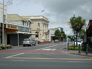
The town centre of Eltham
|
|
| Country | New Zealand |
| Region | Taranaki Region |
| Territorial authority | South Taranaki District |
| Ward |
|
| Community | Eltham-Kaponga Community |
| Electorates |
|
| Area | |
| • Total | 3.43 km2 (1.32 sq mi) |
| Population
(June 2023)
|
|
| • Total | 2,080 |
| • Density | 606.4/km2 (1,571/sq mi) |
| Postcode |
4322
|
Eltham is a small town in South Taranaki, New Zealand. It is about 50 kilometres (31 miles) south of New Plymouth. The town is also southeast of the volcano called Mount Taranaki.
Eltham is the second largest town in South Taranaki. It is famous for being the start of the dairy industry in the Taranaki region. It was also the only place in New Zealand that made rennet. Rennet is an important ingredient used to make cheese. Eltham was also the first place to send butter to England.
Contents
History of Eltham
European settlers started living in Eltham in the 1870s. They cleared the thick forests, mostly north of Mountain Road. Many sawmilling companies helped clear the land. Once the land was cleared and grass grew, it was perfect for dairy farming.
In 1884, Eltham was officially named a town district. More settlers, mainly from England, arrived, and the town had a population of 25 people. Eltham became a borough (a type of town with its own local government) in 1901. Later, in 1989, it became part of the South Taranaki District.
The first roads in New Zealand to be covered with tar were in Eltham. These were High Street and Bridge Street. High Street is part of State Highway 3. It connects Eltham to nearby towns like Stratford and Hāwera. Bridge Street goes west towards Kaponga.
Geography of Eltham
Rivers and Lakes Near Eltham
Two main waterways flow through Eltham: the Mangawharawhara Stream and the Waingongoro River.
The Mangawharawhara Stream flows east of the main railway line. It goes under the town's centre and past Eltham School.
The Waingongoro River forms the western edge of the town. It flows through Taumata Park, which is Eltham's main sports ground and camping area. This river eventually reaches the Tasman Sea at Ohawe Beach.
Eltham is also a good starting point to visit two lakes. One is Lake Rotokare, a beautiful natural lake surrounded by native trees. The other is Lake Rotorangi, which is a lake made by people.
People of Eltham (Demographics)
Eltham covers an area of about 3.43 square kilometres (1.32 square miles). As of 2023, about 2,000 people live there.
In 2018, Eltham had a population of 1,935 people. This was a small increase from 2013. There were 801 households. For every 100 females, there were about 103 males. The average age of people in Eltham was 39.7 years. About 22% of the people were under 15 years old. About 17% were between 15 and 29 years old.
Most people in Eltham are of European (Pākehā) background (79.4%). About 30.2% are Māori. A small number of people are from Pacific Islands or Asia. About 8.4% of people were born outside New Zealand.
Local Services in Eltham
Eltham has a full library and council service. These services are part of the South Taranaki District Council, which is based in Hāwera. You can do many things at the LibraryPlus, like register your dog or pay for building permits. The LibraryPlus is also a New Zealand Post office.
The LibraryPlus offers fun activities like "Tot Time" for young children. They also have "coffee and blog" meetings for people to learn about new technology. You can use computers with free internet and Skype there too.
Industries in Eltham
The main industry in Eltham is making cheese. The Mainland Cheese factory on Bridge Street makes many special cheeses. These include feta and camembert.
Other types of cheese, like the processed cheese used in burgers, are made at another factory on Collingwood Street. This factory used to be a milk powder plant.
To show how important cheese is to the town, Eltham's water tank was painted to look like a giant block of cheese in 2002!
Another important industry in Eltham is the ANZCO (formerly Riverlands) meat processing plant. This plant can process many cattle each day.
Education in Eltham
Eltham School is a school for students from Year 1 to Year 8 (ages 5 to 13). As of 2023, about 200 students attend the school. Eltham School first opened in 1886.
Notable People from Eltham
Many interesting people have come from Eltham, including:
- Amyas Connell (1901–1980), an architect.
- Martin Donnelly (1917–1999), a famous cricketer and rugby player.
- Gavin Hill (born 1965), a rugby union and rugby league player.
- Charles Knight aka Tankboy (born 1967), a television producer.
- Brian Muller (1942–2019), a rugby union player.
- Geoff Old (born 1956), a rugby union player.
- Bryce Robins (born 1980), a rugby union player.
- Ronald Syme (1903–1989), a historian.
- Walter Symes (1852–1914), a politician.
- Chau Tseung (or Chew Chong) (1828–1920), who started the factory system for making butter in the 1880s.
- Roger Urbahn (1934–1984), a rugby union player.
- Stephen Cox (born 1956), a New Zealand Olympic Cyclist.
 | Bessie Coleman |
 | Spann Watson |
 | Jill E. Brown |
 | Sherman W. White |


