Kempt Lake facts for kids
Quick facts for kids Kempt Lake |
|
|---|---|

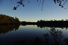
Kempt Lake from the Manawan Indian Reserve
|
|
| Location | Baie-Obaoca / Baie-Atibienne, Matawinie Regional County Municipality, Quebec |
| Coordinates | 47°26′17″N 74°16′45″W / 47.43806°N 74.27917°W |
| Type | reservoir contained by a dam |
| Primary inflows | Manouane River |
| Primary outflows | Manouane River |
| Basin countries | Canada |
| Surface area | 12,000 km2 (4,600 sq mi) |
| Islands | "Aux érables Island" (Maple Island), cedar island and Arikici island |
| Settlements | Obaoca Bay |
Kempt Lake is a large body of water found in Quebec, Canada. It's not a natural lake but a reservoir. This means it was created by building a dam to hold back water. You can find it in the Matawinie area, within the Lanaudière region. The lake is part of the Manouane River (La Tuque) system and is located north of the Rouge-Matawin Wildlife Reserve.
Contents
Exploring Kempt Lake's Geography
Kempt Lake has a unique, uneven shape. It features many peninsulas (land almost surrounded by water) and bays (parts of the lake that curve inward). The lake is home to dozens of islands. The most important ones are "Aux érables Island" (which means Maple Island), Cedar Island, and Arikici Island.
How Kempt Lake Was Formed: The Dams
Kempt Lake is a reservoir, which means its water is held back by dams. These dams are important for controlling the water and generating electricity.
Bay Gavin Dam
The Bay Gavin Dam helps contain Kempt Lake. It is located in the area of Obaoca Bay. This dam was first built in 1908 and is owned by Hydro-Québec, a large electricity company.
- The dam is 4 meters (about 13 feet) tall.
- It can hold 40.7 million cubic meters of water.
- The dam is 73 meters (about 240 feet) long.
- It is made of earth, built on a foundation of natural soil.
- The main purpose of this dam is to help produce hydroelectricity, which is electricity made from moving water.
Manouane-A Dam
A second important dam on Kempt Lake is called Manouane-A. It was built in 1941, also for generating hydroelectricity.
- This dam is 7 meters (about 23 feet) tall.
- It is 108.8 meters (about 357 feet) long.
- The reservoir behind this dam can hold a huge amount of water: 407 million cubic meters.
- The total area of the reservoir is 12,000 hectares (about 46 square miles).
- The area that collects water for this dam is 1,507 square kilometers (about 582 square miles).
Connecting Lakes: The Strait
A narrow stretch of water, called a strait, connects Kempt Lake to Lake Manouane. This strait is 6.1 kilometers (about 3.8 miles) long. If you travel by road from the town of Saint-Michel-des-Saints, Kempt Lake is about 173 kilometers (about 107 miles) away. The road follows the eastern side of Kempt Lake.
The Name of Kempt Lake
The study of place names is called toponymy. The name "Lake Kempt" was officially recorded on December 5, 1968. This was done by the Commission de toponymie du Québec, which is the official board for geographical names in Quebec.
 | Misty Copeland |
 | Raven Wilkinson |
 | Debra Austin |
 | Aesha Ash |


