Keno, Oregon facts for kids
Quick facts for kids
Keno, Oregon
|
|
|---|---|

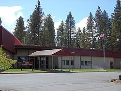
Keno entrance sign, elementary school in the background.
|
|
| Country | United States |
| State | Oregon |
| County | Klamath |
| Area | |
| • Total | 9.57 sq mi (24.79 km2) |
| • Land | 9.25 sq mi (23.96 km2) |
| • Water | 0.32 sq mi (0.82 km2) |
| Elevation | 4,108 ft (1,252 m) |
| Population
(2020)
|
|
| • Total | 1,980 |
| • Density | 213.98/sq mi (82.62/km2) |
| Time zone | UTC-8 (Pacific (PST)) |
| • Summer (DST) | UTC-7 (PDT) |
| ZIP code |
97627
|
| Area code(s) | 458 and 541 |
| FIPS code | 41-38750 |
Keno is a small community in Klamath County, Oregon, in the United States. It's not a city with its own government, but a group of homes and businesses. You can find Keno southwest of Klamath Falls, right by the Klamath River. It's also close to Oregon Route 66.
In 2020, about 1,980 people lived in Keno. The community sits high up, about 4,108 feet (1,252 meters) above sea level.
Keno got its name from a special bird dog. This dog belonged to the first person who ran the post office here. Before being called Keno, the area had other names like Plevna and Whittles Ferry. The Keno post office opened in 1887.
Kids in Keno go to Keno Elementary School. This school teaches children from kindergarten through sixth grade. It is part of the Klamath County School District. In the past, about 188 children attended this school.
Keno's Population
This section shows how many people live in Keno. The numbers come from official counts called the U.S. Decennial Census.
| Historical population | |||
|---|---|---|---|
| Census | Pop. | %± | |
| 2020 | 1,980 | — | |
| U.S. Decennial Census | |||
Keno's Weather
Keno has a climate that brings warm, dry summers. The temperature usually doesn't get super hot, staying below 85°F (29°C) on average during the warmest months.
This type of weather is known as a "dry-summer humid continental climate." It means summers are dry, but there's enough moisture overall.
| Climate data for Keno, OR | |||||||||||||
|---|---|---|---|---|---|---|---|---|---|---|---|---|---|
| Month | Jan | Feb | Mar | Apr | May | Jun | Jul | Aug | Sep | Oct | Nov | Dec | Year |
| Record high °F (°C) | 58 (14) |
62 (17) |
65 (18) |
81 (27) |
85 (29) |
94 (34) |
97 (36) |
99 (37) |
92 (33) |
86 (30) |
61 (16) |
55 (13) |
99 (37) |
| Mean daily maximum °F (°C) | 38.5 (3.6) |
42.6 (5.9) |
45.7 (7.6) |
53.6 (12.0) |
64.5 (18.1) |
74.5 (23.6) |
83.3 (28.5) |
85.1 (29.5) |
83.8 (28.8) |
67 (19) |
44.9 (7.2) |
37.8 (3.2) |
60.1 (15.6) |
| Mean daily minimum °F (°C) | 19.9 (−6.7) |
22.2 (−5.4) |
26.1 (−3.3) |
28.5 (−1.9) |
35.3 (1.8) |
43.3 (6.3) |
48.6 (9.2) |
47.2 (8.4) |
39.9 (4.4) |
31.2 (−0.4) |
25.5 (−3.6) |
19.0 (−7.2) |
32.2 (0.1) |
| Record low °F (°C) | −22 (−30) |
−8 (−22) |
−1 (−18) |
13 (−11) |
16 (−9) |
21 (−6) |
28 (−2) |
30 (−1) |
25 (−4) |
11 (−12) |
−1 (−18) |
−19 (−28) |
−22 (−30) |
| Average precipitation inches (mm) | 2.84 (72) |
1.99 (51) |
1.92 (49) |
1.28 (33) |
1.21 (31) |
0.88 (22) |
0.34 (8.6) |
0.45 (11) |
0.63 (16) |
1.5 (38) |
2.59 (66) |
3.21 (82) |
18.84 (479.6) |
| Average snowfall inches (cm) | 16 (41) |
9.9 (25) |
6.5 (17) |
2.1 (5.3) |
0.2 (0.51) |
0 (0) |
0 (0) |
0 (0) |
0 (0) |
0.5 (1.3) |
6.4 (16) |
13.5 (34) |
55 (140) |
| Average precipitation days | 12 | 10 | 11 | 9 | 7 | 5 | 2 | 2 | 3 | 6 | 11 | 12 | 90 |


