Kerrier Hundred facts for kids
| Kerrier Hundred | |
|---|---|
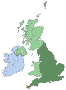
  Shown within UK |
The Kerrier Hundred was an old way of dividing land in Cornwall, United Kingdom. A "hundred" was like a district or area used for managing local government and collecting taxes a long time ago. Kerrier was one of ten such areas in Cornwall.
The name Kerrier (sometimes spelled Kirrier) might come from an old Cornish phrase, "ker hyr," which means "long fort." This probably refers to an ancient fort called Castle Pencaire, located on Tregonning Hill in Breage. It's also thought that an even older name for this area was Predannack, which is now part of the Lizard Peninsula.
What is a Hundred?
A hundred was a traditional way to divide land in England and some other countries. These divisions were used for many centuries, especially for legal and administrative purposes. Each hundred would have its own court and local meetings.
The size of a hundred could vary a lot. Some were very small, while others covered large areas. They were important for local life before modern counties and districts were created.
Towns and Villages in Kerrier
The Kerrier Hundred included many towns and villages. These smaller areas were called parishes. Here are some of the places that were part of the Kerrier Hundred:
- St Anthony-in-Meneage
- Breage
- Budock
- Constantine
- Cury
- Falmouth
- Germoe
- St Gluvias
- Grade
- Gunwalloe (also known as Winnington)
- Gwennap with St Day
- Helston
- St Keverne
- Landewednack
- Mabe
- Manaccan
- St Martin-in-Meneage
- Mawgan-in-Meneage
- Mawnan
- Mullion
- Mylor
- Perranarworthal
- Ruan Minor and Ruan Major
- Sithney
- Stithians
- Wendron
Where Was Kerrier Located?
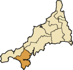
Kerrier Hundred was in the southwest part of Cornwall. It shared borders with other hundreds and was surrounded by the sea on some sides.
 |
Penwith Hundred | Pydarshire Hundred | Powdershire Hundred |  |
| Penwith Hundred | Atlantic Ocean | |||
| Atlantic Ocean | Atlantic Ocean | Atlantic Ocean |
 | Precious Adams |
 | Lauren Anderson |
 | Janet Collins |

