
Breage, Cornwall facts for kids
Quick facts for kids Breage
|
|
|---|---|
 A former Methodist chapel |
|
| Lua error in Module:Location_map at line 530: Unable to find the specified location map definition: "Module:Location map/data/Cornwall (mainland)" does not exist. | |
| Population | Expression error: "String Module Error: Target string is empty" must be numeric () |
| OS grid reference | SW615285 |
| Unitary authority | |
| Ceremonial county | |
| Region | |
| Country | England |
| Sovereign state | United Kingdom |
| Post town | HELSTON |
| Postcode district | TR13 |
| Dialling code | 01326 |
| Police | Devon and Cornwall |
| Fire | Cornwall |
| Ambulance | South Western |
| EU Parliament | South West England |
| UK Parliament |
|


Breage (pronounced BREEG or BRAYG) is a village and civil parish in Cornwall, England. It is about 3 miles (5 km) west of Helston.
The village is named after Saint Breaca. She was a missionary from Ireland. The 15th-century church in Breage is dedicated to her. In 2021, the parish had a population of 3,159 people.
Other small communities in the parish include Ashton, Carleen, and Godolphin Cross. The coastal village of Praa Sands is also part of Breage parish.
Contents
A Look Back in Time
Breage has a long history. In the Domesday Book, a survey from 1086, Breage was part of the Binnerton area. The land was big enough for many farms. Many villagers and small farmers lived and worked there. They had fields, meadows, and woodlands. They also raised animals like horses, cattle, pigs, and sheep. This shows that Breage was a busy farming area long ago.
You can find old Cornish crosses in the parish. One was found in the churchyard and now stands near the church. Another, called Trevena cross, is at a road junction not far from the village.
How Breage is Governed
Breage has a parish council. This is the lowest level of local government. It helps make decisions for the local community. Breage is part of the Cornwall unitary authority area. This means Cornwall Council is the main local government for the whole county.
For elections to Cornwall Council, Breage is in the Porthleven, Breage and Germoe electoral ward. For elections to the Parliament of the United Kingdom, Breage is part of the St Ives constituency. This is the area that elects a Member of Parliament (MP) to represent it in the UK government.
Exploring Breage's Landscape
The land around Breage is special because of a type of rock called Tregonning-Godolphin Granite. This granite is part of a much larger rock formation in Cornwall. Because of this geology, the area was once very important for mining. People mined for tin and copper ore here for over 2,000 years!
Most of the villages in the parish, except Praa Sands, were once mining villages. Breage village itself was where the mine owners, often called "captains," lived. You can still see many fine old buildings that belonged to them. An old village water pump also stands as a reminder of the past.
Today, many people who live in Breage travel to nearby towns for work. They might go to Helston, RNAS Culdrose (a naval air station), Porthleven, Penzance, or Falmouth. Some residents still work in farming in the surrounding countryside.
Ashton is one of the villages in the parish. It is on the A394 road between Penzance and Helston. Ashton has a pub called the Lion and Lamb.
Villages and Hamlets in Breage Parish
The parish of Breage includes several smaller communities:
- Ashton
- Broadlane
- Carleen
- Godolphin Cross
- Gwedna
- Hendra
- Kenneggy
- Millpool
- Pengersick
- Penhale Jakes
- Polladras
- Praa Sands
- Rinsey
- Rinsey Croft
- Trenwheal
- Trescowe
- Tresoweshill
- Trevena
- Trew
Special Protected Areas
Some areas in Breage parish are protected because they are important for nature or geology.
- Tregonning Hill, to the west, is a Site of Special Scientific Interest (SSSI). It was given this special status in 1994 because of its interesting plants and animals.
- Tremearne Par SSSI and Porthcew SSSI are along the coast. They are protected because of their unique geological features.
- Great Wheal Fortune was a small mine that operated between 1855 and 1880. It produced tin, copper, and other minerals. In 1991, it became an SSSI because of its national importance.
Churches and Schools
.jpg)
The main church in the village is St Breaca's Church. It was built in the 15th century using granite. Inside, on the north wall, you can see five old medieval wall paintings.
The church also has a Roman milestone from the 3rd century. This stone suggests that a Roman road might have been nearby long ago. In the churchyard, there is a very old and unusual cross head.
There is also a Methodist church in the village called Breaney Methodist chapel. It is on Trevithick Road.
The local primary school for children is Breage Church of England VA Primary School. It was first started in the 1840s.
Well-Known People from Breage
- Sidney Godolphin was a poet and courtier (someone who attended a royal court). He was baptized in Breage.
- Major-General David Tyacke was a military officer. He was born and buried in Breage. His family had been involved in tin-mining in the area for a long time.
See also
 In Spanish: Breage para niños
Images for kids
-
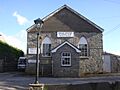
A former Methodist chapel
-
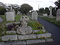
The cross in the churchyard
-
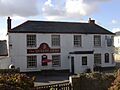
The Queen's Arms Public House in Breage
-
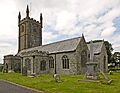
St Breaca's Church
