
Porthleven facts for kids
Quick facts for kids Porthleven
|
|
|---|---|
| Port | |
 Porthleven Harbour |
|
| Lua error in Module:Location_map at line 530: Unable to find the specified location map definition: "Module:Location map/data/Cornwall (mainland)" does not exist. | |
| Population | 3,059 (2011 Census including Ashton and Balwest) |
| OS grid reference | SW6225 |
| Civil parish |
|
| Unitary authority | |
| Ceremonial county | |
| Region | |
| Country | England |
| Sovereign state | United Kingdom |
| Post town | HELSTON |
| Postcode district | TR13 |
| Dialling code | 01326 |
| Police | Devon and Cornwall |
| Fire | Cornwall |
| Ambulance | South Western |
| EU Parliament | South West England |
| UK Parliament |
|
Porthleven is a town and fishing port in Cornwall, England. It is the most southerly port in Great Britain. In the past, this part of the Cornish coast was known for many shipwrecks. Porthleven's harbour offered a safe place for ships during storms.
The South West Coast Path, a long walking trail, goes through the town. In 2011, about 3,059 people lived in Porthleven.
Contents
A Look at Porthleven's History
The area around Porthleven has a long history. A place called Methleigh held a fair and market as early as 1066. After the Norman Conquest, the Bishop of Exeter owned the land. However, the Earl of Cornwall had the right to hold the market.
In 1842, the parish Church of St Bartholomew was built in Porthleven. The town's name might come from St Elwen or Elwyn. There was a chapel dedicated to this saint here before 1270. It was rebuilt around 1510 but later destroyed.
For many years, Porthleven was part of the nearby town of Helston. But as Porthleven grew, it gained its own town council. In 2001, its population was 3,190.
The Bickford-Smith Institute
Porthleven's most famous building is the Bickford-Smith Institute. It stands right next to the pier and the harbour entrance. This building opened on December 16, 1884. Its clock tower on the west side is about 70 feet (21 metres) tall.
The Institute used to have a reading room and other spaces. Today, it houses the town council and a snooker club. You might have seen pictures of it on TV weather forecasts. Sometimes, a photo of the building with huge waves crashing against it appears.
A special plaque on the Institute honours Guy Gibson. He was the leader of the famous "Dambuster Raid" during World War II. Gibson was born in India, but his mother was from Porthleven. He considered it his home town. A street in Porthleven, Gibson Way, is named after him.
Porthleven Harbour's Past
The harbour was important for trade. William Cookworthy used it to ship china clay from nearby quarries. This clay was used to make porcelain in Plymouth. In 1826, 150 tons of china stone and 30 tons of china clay were sent out. By 1883, over 1,000 tons were exported. Granite from local quarries was also shipped from Porthleven.
Porthleven was also a centre for building fishing boats. Between 1877 and 1883, 52 fishing boats were built here. These boats were made for ports in Mount's Bay and other places, even South Africa.
The harbour can be very dangerous during bad storms. In December 1978, two police officers lost their lives when their car was swept into the harbour during a severe storm. A stone memorial on the harbour wall remembers them.
The Lifeboat Station
Because of strong westerly winds, ships sailing in Mount's Bay could easily get trapped and wrecked. To help, the Royal National Lifeboat Institution (RNLI) opened a lifeboat station in Porthleven in 1863.
The first lifeboat was called the Agar Robartes. Later, it was replaced by the Charles Henry Wright. In 1894, a new boathouse with a slipway was built to make launching the lifeboat easier.
The station closed in 1929. This was because nearby lifeboat stations at The Lizard and Penlee had new motor lifeboats. These modern boats could cover the whole bay. The old boathouse is now a museum called the Shipwreck Centre.
Porthleven's Protected Natural Areas
Porthleven is surrounded by important natural sites. Three areas near the town are called Sites of Special Scientific Interest (SSSI). These areas are special because of their unique geology (rocks and landforms). They include Porthleven Cliffs SSSI and Wheal Penrose SSSI.
The Giant's Rock, found within Porthleven Cliffs SSSI, is a huge rock. No one knows exactly where it came from or how it got there. It is a glacial erratic, meaning it was moved by a glacier a long time ago.
Loe Pool is Cornwall's largest natural lake. It was formed by a sand and shingle bank called Loe Bar. This bar dams the River Cober.
Porthleven is also part of the Cornwall Area of Outstanding Natural Beauty (AONB). This means the area has beautiful landscapes that are protected.
Sports and Fun in Porthleven
Porthleven is famous for its great surfing waves. It's known as "Cornwall's best reef break." Waves can often be taller than 6.6 feet (2 metres). These waves break over a shallow reef that was shaped when the harbour was built. Kayaking is also a popular activity here. RNLI lifeguards keep the beach safe during holidays.
The beach is separated from the harbour by a granite pier. When the tide is low, you can walk about three miles (5 km) east along Porthleven beach. There's also a coastal path with amazing views of the beach below.
Porthleven has a Bowling Club at Methleigh Parc. It was started in 1959 and offers both lawn bowling and short-mat bowls. Members compete in local and national events.
The town also has a non-league football club called Porthleven F.C.. They play in the South West Peninsula League. Their home ground is Gala Parc.
Cornish wrestling tournaments were traditionally held in a place called the "Wrestling Field." Today, tournaments sometimes take place at the Recreation Ground.
A famous chef, Rick Stein, used to have a restaurant in Porthleven. Another well-known chef, Michael Caines, has now taken it over.
Twin Town
Porthleven is twinned with Guisseny (Gwiseni) in Brittany, France.
Famous People from Porthleven
Several notable people have connections to Porthleven. These include:
- Pender Hodge Cudlip: A Victorian theologian (someone who studies religion).
- David Jewell: A headmaster of independent schools in the late 20th century.
- Guy Gibson: The commanding officer of the "Dambusters" during World War II. He considered Porthleven his home town.
- Chris Craft: A motor racing driver born in Porthleven. He raced in the 24 Hours of Le Mans for over ten years. He finished third in 1976 and also competed in two Formula One races.
Gallery
-
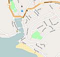
OpenStreetMap of Porthleven
-
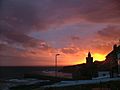
Sunset behind Porthleven clock tower and overlooking Mount's Bay
-
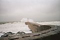
Waves hitting the Pier
-
Porthleven Harbour
-
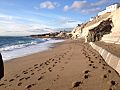
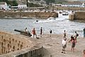
Porthleven Beach


See also
 In Spanish: Porthleven para niños
