Khuiratta Tehsil facts for kids
Quick facts for kids
Khuiratta
کھوئی رٹہ
Khoi ratta
|
|
|---|---|
| Country | Pakistan |
| State | Azad Kashmir |
| District | Kotli |
| Population
(2017)
|
|
| • Total | 8,220 |
| Time zone | UTC+5 (PST) |
| Postal Code |
11200
|
| Area code(s) | 0092-5826 |
| Website | District Website |
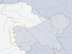
Khuiratta, also called Khoi ratta, is a town in Azad Kashmir, a region managed by Pakistan. It is a Tehsil, which is like a sub-district, within the Kotli District.
Contents
Where is Khuiratta Located?
Khuiratta is about 29 kilometers (18 miles) southeast of Kotli city. It is also around 154 kilometers (96 miles) from Islamabad, the capital of Pakistan. This town is quite close to the Line of Control (LOC), which is a temporary border. It is only about 7 kilometers (4.3 miles) away from this line.
Khuiratta is the second largest town in Kotli District, after Kotli City itself. It sits about 2,570 feet (783 meters) above sea level. The town is located on the western side of Rajouri, which is in Indian-administered Kashmir. To its west is Tehsile Charhoi, and to the east is Rajouri. Noshehra is to the south, while Tehsile Nakyal is to the northeast. Kotli is to the northwest.
How to Get Around Khuiratta
Khuiratta is connected to Kotli and Nakyal by a circular road. You can also reach Mirpur, which is about 80 kilometers (50 miles) away, using two different routes. One route goes through Dhongi and Charhoi, and the other goes via Darghoti and Charhoi.
The town is also linked to other smaller places like Chirri, Seri, Battal, Ghaian, and Khor Gumbi Bhera. In the past, Khuiratta was connected to Rajouri in Indian-administered Kashmir through Seri. However, this road is now closed at a point called Janjoot Bhadar because of the Line of Control.
Villages and Communities in Khuiratta
Khuiratta is surrounded by many villages and smaller towns. Some of these include Ropari Village, Kot Bhattian, Chattar, Seri'broatgalla, Khore, Karjai, Bindian, Gahyain, Plana, Dhanna, Brahi, Battal, Chirri, Sammlar, Brute, Bhayyal, Manjwal, Sehoore, Dharra, Fateh Pur Dehari, Bandli, Ghoara, and Roshan-Abad (which used to be called Andah).
Places to Visit
If you visit Khuiratta, some interesting places to see are Karjai Fort, Battal Brahi, Planna, Kot-Bhattian, Darghoti, and Kot. Darkalla is another place located in a valley known as Wadi e Banah.
Many smaller villages in Khuiratta have mosques. They are also home to shrines, which are special places where religious scholars are remembered. Some of these include the shrine of Mian Imam Baksh near Tokahn and the shrine of Baba Ali Lashkar in Dheri Sahibzadian. There is also a shrine for Pir Haider Shah in Dehari Bagh and Sheikh Alai Jee in Khuiratta. You can also find the shrine of Mai Toti, known as Darbar Mai Toti Sahiba, and the shrine of Baba Ghoray Shah Badshah. Other shrines include Rahaman Baba, Meeraan Aashiq Ali Badshah, and Sain Sadiq.
Khuiratta's Geography
Khuiratta has a landscape with many mountains. It is very close to the Line of Control (LOC), which is the temporary border between Indian-administered Kashmir and Azad Kashmir. The distance is only about 8 kilometers (5 miles).
There are several notable small towns and villages in this area. These include Dehari Baagh, Damandah, Bindian, Gurah, Gitran, Hujra, Merah, Biyal, Manjwaal, Gheyaien, Karjai, Samryali, Hill village, Kotla, Bna Hill, Broat Gala, Anderla Kotehra, Phalni, Seri, Manjwar, Bandli, Saidpur, Darkala, Bain Thalla, Sehore, Phehan, Hill Mughalan, Banni Bannah, Khore Bhera, Dhaana, Roshan Abad (formerly Andha), Gohra, Pathan Mohrha, Barooth, Katasery, Chirri, Battal, Barie, Samlaar, Plaana, Darbar Mai Toti, Taeen, Darkoti, Darkoti Bala, Maraal, Dharaa, Khore Kalla Chamber, Nidi Sohana, Khore Rachalla, Khore Graan, Morah Bakhshiyan, Ruknabad, Sarootiyan, Gangal, Gajiyari, Bandali, Mohajar Colony, Hilla Ghair, and Chakranda.
Khuiratta is connected to Kotli in a few ways: through Dongi, via the Battal-Dhanna Road, and through Nakyal. It is also connected to the main road that leads to Jammu.
Needi Sohana is a local council area in Khuiratta. It is also the highest point in the Kotli district. The Khui Forest is located within this area.
Healthcare in Khuiratta
A few years ago, the Aziz Welfare Trust started building a large hospital in Khuiratta. However, the project faced challenges and is currently just a building. Today, an international community health center called RAHMA Basic Health Center provides important health services. This center offers free medical advice, medicine, and lab tests to people in Khuiratta and nearby areas. It was made possible by Mr. Muhammad Saghir Qamar, Chairman of RAHMA Islamic Relief, Pakistan, and with help from friends in Norway.
Education in Khuiratta
Khuiratta has good educational facilities for young people. There are two government degree colleges, one for boys and one for girls. In addition, there are four private colleges. The town also has two high schools for boys and girls, along with several English medium schools.
Some of the well-known schools and colleges include BA Queens School & College, Pasban Science School & College, The Holy Public School & College, Stars Academy, Pasban School, Suffa Academy & Science College, National Science College, Pakland School, Ideal Public School, Allama Iqbal Public School & College, and Unique Reformer Public School. One of the oldest government schools is the "Government High School Khuiratta." The Pakistan Army has also helped improve education by adding the Army Public School.
Important Religious Figures
Khuiratta is also known for several important religious figures, often called pirs or faqirs. These include Mai Toti Sahiba, Baba Ali Lashkar Sahib, Sangan Darbar, Sain Rukan Deen Sahib, Sain Sakhi Sahib, and Chamby Wali Darbar (Hujra Sharif).
Khuiratta's History
Before Pakistan and India became independent in 1947, Khuiratta was an important trade route. It was used for trading goods between Rajouri and Mirpur.
 | Madam C. J. Walker |
 | Janet Emerson Bashen |
 | Annie Turnbo Malone |
 | Maggie L. Walker |


