Kotli District facts for kids
Quick facts for kids
Kotli
|
|
|---|---|

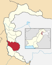
Map of Azad Kashmir with Kotli highlighted
|
|
| Country | Pakistan |
| Established | 1975 |
| Area | |
| • Total | 1,862 km2 (719 sq mi) |
| Population
(1998)
|
|
| • Total | 640,000 |
| • Density | 352/km2 (910/sq mi) |
| Time zone | UTC+5 (PST) |
| Number of Tehsils | 5 |
Kotli (Urdu: ضلع کوٹلی) is an important district in Azad Kashmir, Pakistan. It is known for its beautiful landscapes. The city of Kotli is the main city of this district. It used to be a smaller town. Now, Kotli has grown quite a lot. It is located between Mirpur and Muzaffarabad.
About Kotli District
The Kotli district has an interesting history. It was once a smaller part of the Mirpur District. This changed in 1975, when Kotli became its own district. Before 1947, it was part of the Jammu area.
Where is Kotli Located?
Kotli district is surrounded by different areas. To the east, it borders the Indian part of Kashmir. To the south, you'll find Mirpur District. To the north, it borders Rawalakot.
How Big is Kotli?
The total area of Kotli district is about 1862 square kilometers. This makes it a significant part of Azad Kashmir. Kotli is also the largest city in the district by population. Around 656,000 people live here.
Parts of Kotli District
The district is divided into smaller areas called tehsils. Think of them like sub-divisions or smaller regions within the district. These tehsils help manage the different parts of Kotli.
Before the division of Kashmir in 1947, Nakyal was part of a different sub-division called Mehndar, which was in Poonch.
 | Tommie Smith |
 | Simone Manuel |
 | Shani Davis |
 | Simone Biles |
 | Alice Coachman |

