
Kildrum facts for kids
.jpg)
Kildrum is a neighbourhood in Cumbernauld, Scotland. It was the very first area built when Cumbernauld was created as a "new town." New towns were special places planned and built after World War II to help people find homes and jobs. Kildrum was designed to house workers for the Burroughs factory, which was the first big factory in Cumbernauld.
The main road in Kildrum looks like a big curve. Many smaller streets branch off from this main road. Inside the curve, you'll find houses that were originally built by the local council. Outside the curve, there are often newer, privately owned homes. A cool fact about Kildrum is that its street names are inspired by places linked to the famous Scottish poet, Robert Burns.
Kildrum has many useful places for its residents. These include Cumbernauld High School, a primary school, and a special school. There's also a health centre, a YMCA, and several shops. You can find hairdressers, a chemist, and different churches or chapels, including the Salvation Army.
Kildrum's story goes back much further than the new town. On October 1, 1310, a very important letter was written from Kildrum! Robert the Bruce, a Scottish king, wrote to Edward II of England. He was trying to make peace between Scotland and England, but it didn't work out at that time. There was also an old farm in Kildrum, and we still have some records about it.
Kildrum is surrounded by other parts of Cumbernauld. The main Town Centre and Carbrain are to its west. To the north, you'll find Seafar. On the east side is Cumbernauld Park, and to the south is Cumbernauld Glen, a lovely natural area.
Contents
Exploring Kildrum's Streets

Kildrum has many streets, each with its own character and sometimes a special facility. Many of these street names, as mentioned, connect to the poet Robert Burns.
Main Roads and Important Places
- Kildrum Road: This is the main road that curves through the area.
- Lochlea Road: Here you will find the Kildrum Health Centre, which is important for local healthcare.
- Ellisland Road: This street is home to Kildrum Primary School, where many local children go to learn.
- Kenmore Road: The Kildrum Parish Church is located on this road.
Other Residential Streets
- Tarbolton Road
- Kyle Road: Sacred Heart Church is on this road.
- Campsie View
- Afton Road: You can find a shop and the YMCA here.
- Braehead Road: This street has a shop, a hall, and a hairdresser. There's also a theatre nearby.
- Park Way
- Castle Way
- Meadow View
- Ainslie Road
- Forest View
- Glen View
- Burn View
- Maclehose Road
- Glencairn Road
- Moss Knowe
- Lamerton Road
- Clouden Road: The Salvation Army and another shop are located here.
- Mossgiel Road
- Doon Side
- Corbiston Way: This street also has a shop.
Images for kids
-
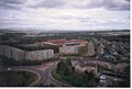
View from the top of Stuart House in 1992, looking north-east over Kildrum
.jpg)
