
Carbrain facts for kids
Quick facts for kids Carbrain |
|
|---|---|
 South Carbrain's Millcroft Road flats viewed from Cumbernauld railway station |
|
| Council area | |
| Lieutenancy area | |
| Country | Scotland |
| Sovereign state | United Kingdom |
| Post town | GLASGOW |
| Postcode district | G67 |
| Dialling code | 01236 |
| Police | Strathclyde |
| Fire | Strathclyde |
| Ambulance | Scottish |
| EU Parliament | Scotland |
| UK Parliament |
|
| Scottish Parliament |
|
Carbrain is a neighborhood located in Cumbernauld, North Lanarkshire, Scotland. Long ago, in the 1700s, it was just a small mention on an old map. By the 1800s, it was mostly a farm with only a few buildings. Even in 1956, Carbrain was still mostly farmland with a small stream flowing through it.
Building a New Community
In the 1960s, designers Derek Lyddon and James Latimer planned many of the homes in Carbrain. Building started in 1963. By the early 1970s, most areas of Carbrain had people living in them.
At first, Carbrain was a very popular place to live. Many people moved there from Glasgow to find better housing. Over time, newer areas were built in Cumbernauld. Carbrain then started to look a bit old, even with some updates. For example, over £70 million was spent to build new homes around Beechwood Court. An interesting artwork called Vitruvian Girl by Andy Scott watches over this area. There are also plans to update Millcroft Road.
Exploring Carbrain's Layout
Carbrain has ten main living areas. You can find four churches here: Carbrain Baptist Church, Cumbernauld Free Church, Cumbernauld United Reformed Church, and St. Joseph's. There are also two pubs, The Twa Corbies and The Jack Snipe. Many small shops are spread throughout the area. You can also find community buildings like the Red Cross Centre. Carbrain was designed to have the main Town Centre as its focus. This meant there was no need for very large entertainment places or big grocery stores within Carbrain itself.
.jpg)
Carbrain is divided into two main parts: North and South.
- North Carbrain was built first. It includes roads like Glenhove Road, Torbrex Road, and Beechwood Road. This part is very close to the Town Centre, health center, and sports center, usually within a five-minute walk.
- South Carbrain includes roads like Millcroft Road and Greenrigg Road. Some parts of South Carbrain are just a five-minute walk from the train station. The Town Centre is about a ten-minute walk from South Carbrain.

Carbrain was designed to be very friendly for people walking. It has many paths that connect different streets. You can walk from one part of Carbrain to another using only these footpaths. The design also made sure that people walking never had to walk next to busy roads or cross them directly.
Schools and Community
The area of Hillcrest was never officially part of Carbrain. However, a temporary school in Carbrain became Hillcrest Primary in 1971. Because of this, there is a community council for "Carbrain and Hillcrest."
There were three primary schools in this area. Most children living here would have gone to Langlands Primary, St Joseph's Primary, or Carbrain Primary. Carbrain Primary celebrated its 50th birthday in 2016. After primary school, students would often go to Cumbernauld High School, Greenfaulds High School, or Our Lady's High School. St Margaret of Scotland Primary later replaced St Joseph's Primary.
Carbrain also has a voluntary football club called Carbrain Boys Club.
Images for kids
-
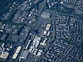
Cumbernauld town centre from above, with South Carbrain on the right.
.jpg)
