Kimbolton, Ohio facts for kids
Quick facts for kids
Kimbolton, Ohio
|
|
|---|---|

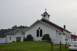
Methodist church on Main Street
|
|
| Country | United States |
| State | Ohio |
| County | Guernsey |
| Township | Liberty |
| Area | |
| • Total | 0.50 sq mi (1.29 km2) |
| • Land | 0.50 sq mi (1.29 km2) |
| • Water | 0.00 sq mi (0.00 km2) |
| Elevation | 801 ft (244 m) |
| Population
(2020)
|
|
| • Total | 152 |
| • Density | 305.22/sq mi (117.93/km2) |
| Time zone | UTC-5 (Eastern (EST)) |
| • Summer (DST) | UTC-4 (EDT) |
| ZIP code |
43749
|
| Area code(s) | 740 |
| FIPS code | 39-40264 |
| GNIS feature ID | 2628910 |
Kimbolton is a small place in Guernsey County, Ohio, United States. It is known as an unincorporated community and a census-designated place. This means it's a recognized area for gathering population data, but it doesn't have its own city government. Kimbolton is located along Wills Creek. In 2020, about 152 people lived there.
History of Kimbolton
Kimbolton was first planned out in 1828. It was originally named "Liberty." John Gibson was the person who first designed the layout of the town.
A post office opened in Kimbolton in 1837. The village was officially made a town in 1884. The name "Kimbolton" comes from a town in England called Kimbolton. A local merchant who lived there was from that English town.
In March 2004, the people living in Kimbolton voted to give up their village government. They decided to let the leaders of Liberty Township manage the area instead. The village officially stopped being a separate town on April 30, 2005.
Geography of Kimbolton
Kimbolton is located in the northern part of Guernsey County. It is also in the northern part of Liberty Township. You can find it on Ohio State Route 541.
The area is about 1 mile (1.6 km) west of Interstate 77. This highway goes south about 9 miles (14 km) to Cambridge. Cambridge is the main city in Guernsey County. Interstate 77 also goes north about 28 miles (45 km) to New Philadelphia.
According to the United States Census Bureau, the Kimbolton area covers about 0.50 square miles (1.29 square kilometers). All of this area is land.
Population and People
| Historical population | |||
|---|---|---|---|
| Census | Pop. | %± | |
| 2020 | 152 | — | |
| U.S. Decennial Census | |||
In the year 2000, there were 190 people living in Kimbolton. These people lived in 57 households, and 44 of these were families. The population density was about 794 people per square mile (306 people per square kilometer).
Most of the people living in Kimbolton in 2000 were White (about 91.58%). A smaller number were African American (2.63%), from other races (1.05%), or from two or more races (4.74%).
The average age of people in the village in 2000 was 40 years old. About 24.2% of the population was under 18 years old. Also, 25.3% of the people were 65 years old or older.
See also
 In Spanish: Kimbolton (Ohio) para niños
 | Shirley Ann Jackson |
 | Garett Morgan |
 | J. Ernest Wilkins Jr. |
 | Elijah McCoy |


