
Kimihia railway station facts for kids
Quick facts for kids
Kimihia Railway Station
|
|||||||||||
|---|---|---|---|---|---|---|---|---|---|---|---|

Aerial view of Fisher Road in 1941 (centre-right of photo). The white patches to the south of the road were probably the site of the station until 1939
|
|||||||||||
| Location | Huntly New Zealand |
||||||||||
| Coordinates | 37°31′00″S 175°09′57″E / 37.516555°S 175.165759°E | ||||||||||
| Elevation | 11 m (36 ft) | ||||||||||
| Owned by | KiwiRail Network | ||||||||||
| Line(s) | North Island Main Trunk | ||||||||||
| Distance | Wellington 577.92 km (359.10 mi) | ||||||||||
| Tracks | double track from 27 August 1939 | ||||||||||
| History | |||||||||||
| Opened | 13 August 1877 | ||||||||||
| Closed | 27 August 1939 | ||||||||||
| Services | |||||||||||
|
|||||||||||
Kimihia Railway Station was a train stop located north of Huntly in the Waikato District of New Zealand. It was part of the important North Island Main Trunk railway line. The station was about 1.4 km (0.87 mi) north of where the Kimihia coal branch line joined the main railway.
The station's exact spot was a bit unclear. Some records placed it near Fisher Road and SH1. Other information suggested it was closer to Huntly, where Kimihia Road crossed the railway tracks. This road crossing was closed to traffic in 1945.
Contents
History of Kimihia Station
The Kimihia Railway Station first opened on 13 August 1877. This happened when the main railway line was extended from Mercer to Ngāruawāhia. The station was built on land that belonged to Robert Reilly Ralph, who later owned a coal mine nearby.
Kimihia was not a busy station. It often didn't appear on train timetables. This meant that passenger trains usually didn't stop there.
Becoming a Flag Station
In 1894, people asked for Kimihia to become a "flag station." A flag station is a small stop where trains only stop if a passenger waves a flag to get on, or if someone on the train tells the conductor they want to get off there.
By 1895, trains started stopping at Kimihia Siding for school children. It officially became a flag station on 7 February 1896. By the end of that year, it had a small shelter shed for passengers and a platform. It also had a "passing loop," which is an extra section of track. This loop allowed trains to wait while another train passed by on the main line. This first loop could hold 37 wagons.
Station Closure
To help trains move more smoothly, a longer passing loop was built in 1929. This new loop could hold 72 wagons. Work began in 1937 to add a second track to the railway line going north.
Kimihia Railway Station closed on 27 August 1939. This was the same day that the double track system began between Ohinewai and Huntly. In 1944, the area where Kimihia was located became part of Huntly Borough.
Kimihia Coal Mine Branch Line
A special railway line was built to connect the main railway to a coal mine. Permission to build this mine branch was given in 1885.
Early Coal Mining
The first part of this branch line was about 1 mi 76 ch (3.1 km) long. It went around the southern edge of Lake Kimihia to the Taupiri Reserve Colliery Co. mine. This mine opened on 1 August 1887 and the branch line was called the Taupiri Branch. Unfortunately, that mine closed in 1910 because of a fire.
Later Coal Mining
State Coal Mines started a new type of mine in 1943. This was an opencast mine, which means coal is dug up from the surface rather than from underground tunnels. This new mine was built to get the coal that the previous mine had left behind.
The opencast mine started producing coal in 1944. An agreement was made to use the Taupiri Coal Co's railway sidings. However, the branch line itself wasn't reopened until 1946. The opencast mine closed in 1977. It was replaced by the Huntly East Mine in 1978.
Modern Use and Closure
On 21 August 1979, the first train carrying coal from the new mine used the branch line. This line started about 3 km (1.9 mi) north of Huntly and stretched 3.58 km (2.22 mi) east to the coal loading area. From 7 July 1981, the Railway Corporation took over looking after the branch line from the Mines Department.
Until 2013, the mine produced about 450,000 tonnes of coal each year. About 95% of this coal was sent by train to the Glenbrook steel mill. The mine's closure was announced on 8 October 2015, and the branch line officially closed on 21 October 2015. The tracks, which were about 3 km (1.9 mi) long, were removed in 2017.
Images for kids
-
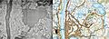
The Kimihia railway branch line can be faintly seen in the 1941 aerial photo. It follows the same route as the line open from 1946 to 2017, as shown on the 2018 Topomap. The lake was largely drained for opencast coal mining.
-
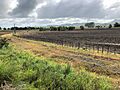
A 2019 view of the Kimihia Branch line from the North Island Main Trunk (NIMT).

