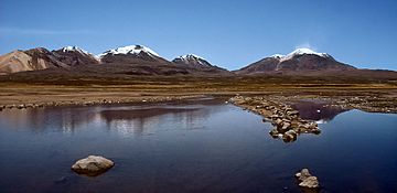
Kimsa Chata (Bolivia-Chile) facts for kids
Quick facts for kids Kimsa Chata |
|
|---|---|

The Kimsa Chata volcanic group
|
|
| Highest point | |
| Elevation | 6,052 m (19,856 ft) |
| Geography | |
| Location | Chile |
| Parent range | Andes |
| Geology | |
| Mountain type | Stratovolcano |
Kimsa Chata or Kimsachata is a group of three volcanoes. Its name comes from the Aymara and Quechua word kimsa, meaning "three", and the Pukina word chata, meaning "mountain". So, Kimsa Chata means "three mountains".
This volcanic group stretches about 8 kilometers (5 miles) from north to south. It sits right on the border between Bolivia and Chile. From these mountains, you can see Chungara Lake. All three peaks in this group are a type of volcano called a stratovolcano.
Contents
The Three Peaks of Kimsa Chata
The Kimsa Chata group includes three main peaks. They are lined up from north to south. Each one is a tall volcano.
Umurata: The Northern Peak
The northernmost peak is called Umurata. It stands at about 5,730 meters (18,799 feet) tall.
Acotango: The Highest Peak
In the middle of the group is Acotango. This is the tallest peak of the three, reaching 6,052 meters (19,856 feet) high.
Capurata: The Southern Peak
The southernmost peak is Capurata. It is also known as Cerro Elena Capurata. This peak is about 5,990 meters (19,652 feet) tall.
Nearby Volcanoes
It is important to know that the active volcano Guallatiri is not part of the Kimsa Chata group. Guallatiri is located to the west of Capurata.
See also
 In Spanish: Nevado Quimsachata para niños
- List of volcanoes in Bolivia
- List of volcanoes in Chile
- Kuntur Ikiña
Sources
 | Emma Amos |
 | Edward Mitchell Bannister |
 | Larry D. Alexander |
 | Ernie Barnes |

