
King Haakon Bay facts for kids
Quick facts for kids King Haakon Bay |
|
|---|---|
 |
|

King Haakon Bay
Location in South Georgia Island
|
|
| Coordinates | 54°09′S 37°19′W / 54.150°S 37.317°W |
| Ocean/sea sources | Scotia Sea |
| Islands | South Georgia Island |
King Haakon Bay, also known as King Haakon Sound, is a long inlet on the southern coast of South Georgia Island. An inlet is like a narrow arm of the sea that stretches inland. This bay is about 8 miles (13 kilometers) long and 2.5 miles (4 kilometers) wide.
Naming King Haakon Bay
This bay was named after King Haakon VII of Norway. He was the first king of Norway after it became independent in 1905. The bay was named by Carl Anton Larsen, who was a Norwegian explorer. Larsen also founded Grytviken, which was a whaling station on South Georgia Island. Close to King Haakon Bay, you can find Queen Maud Bay, which was named after King Haakon's queen.
Shackleton's Amazing Journey
King Haakon Bay is famous because of a brave explorer named Sir Ernest Shackleton. In May 1916, Shackleton landed at a place called Cave Cove, which is part of the bay. He was on an incredible journey to get help for his crew.
Shackleton's ship, the Endurance, had been crushed by ice near Elephant Island. His crew was stranded there. Shackleton and a small group sailed in a lifeboat called the James Caird for 17 days across rough seas to reach South Georgia. Landing in King Haakon Bay was a huge step in their rescue mission. They also camped at a spot called Peggotty Bluff inside the bay.
From King Haakon Bay, Shackleton and two others had to cross the mountains of South Georgia to reach the whaling station at Grytviken. A mountain pass called Shackleton Gap connects King Haakon Bay to Possession Bay. This difficult journey helped save his shipwrecked crew.
Images for kids
-
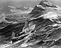
The James Caird nearing South Georgia, from Ernest Shackleton's book, South, 1919.

See also
 In Spanish: Bahía Rey Haakon para niños
