Possession Bay facts for kids
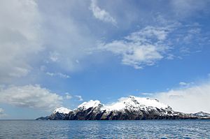
Possession Bay is a bay about 2 kilometers (1.2 miles) wide on the north coast of South Georgia. South Georgia is an island in the southern Atlantic Ocean. The bay stretches southwest for about 5 kilometers (3.1 miles). It is separated from Cook Bay by a place called Black Head. A mountain pass called Shackleton Gap connects Possession Bay to King Haakon Bay.
Exploring Possession Bay
Many parts of Possession Bay and its surroundings have been mapped by different groups exploring the Antarctic.
Black Head is a dark, rough piece of land that sticks out into the sea. It's about 60 meters (197 feet) high. It separates Possession Bay from Cook Bay, which is to the north.
At the very end of Possession Bay, you'll find Inner Reef. This reef goes from Adventure Point on the west side to Brown Point on the east side. Just south of Adventure Point is Brighton Beach. This beach stretches to Zero Point. Zero Point is on the north side of Assistance Bay, which is a smaller bay inside Possession Bay.
On the east side of the bay, Alert Point marks where the Purvis Glacier meets the sea. Outer Moraine Reef goes from Alert Point to Steep Point. Brown Point is located between Steep Point and Glacier Point.
How Places Got Their Names
Brighton Beach was named by explorers from the Discovery Investigations between 1926 and 1930. They thought the beach looked as busy with animals as Brighton, a popular beach resort in England. The explorers also named Alert Point after their survey motorboat, the Alert. The names Zero Point and Black Head also appeared on maps from the same expedition.
Captain Cook's Visit in 1775
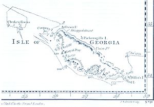
Possession Bay was discovered and named by a British expedition led by Captain James Cook in 1775. Cook made the first known landing on South Georgia near this bay.
Captain Cook, sailing on HMS Resolution with HMS Adventure, was the first to land, explore, and map South Georgia. On January 17, 1775, he officially claimed the island for Britain. He renamed it "Isle of Georgia" in honor of King George III.
German naturalist Georg Forster was with Cook during their landings at three different spots in Possession Bay that day. He wrote: "Here Captain Cook displayed the British flag, and performed the ceremony of taking possession of those barren rocks, in the name of his Britannic Majesty, and his heirs forever. A volley of two or three muskets was fired into the air."
Captain Cook himself wrote in his ship's log: "The head of the Bay... was ended by a huge Mass of Snow and ice of vast extent. It showed a straight cliff of considerable height, just like the side of an ice isle. Pieces were continually breaking from them and floating out to sea. A great fall happened while we were in the Bay; it made a noise like Cannon. The inner parts of the Country were not less wild and terrible... the wild rocks raised their high tops until they were lost in the clouds, and the valleys lay buried in everlasting snow. Not a tree was to be seen nor a shrub even big enough to make a tooth-pick."
See also
 In Spanish: Bahía de la Posesión para niños
 | George Robert Carruthers |
 | Patricia Bath |
 | Jan Ernst Matzeliger |
 | Alexander Miles |


