King Solomon's Dome facts for kids
Quick facts for kids King Solomon's Dome |
|
|---|---|

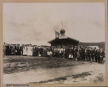
Shriner's excursion to King Soloman's Dome Aug. 4, 1910
|
|
| Highest point | |
| Elevation | 1,234 m (4,049 ft) |
| Naming | |
| Native name | Error {{native name}}: an IETF language tag as parameter {{{1}}} is required (help) |
| Geography | |
| Location | Yukon, Canada |
| Topo map | NTS 115.O.15 |
King Solomon's Dome, also called King Solomon Dome, is a mountain peak in Canada's Yukon Territory. Its name in the local Hän language is Ch'ë`gaa tsòk. This peak stands 1,234 meters (4,049 feet) tall.
The mountain is located about 32 kilometers (20 miles) southeast of Dawson City, Yukon. Many people believe this mountain was the main source of gold that started the famous Klondike Gold Rush around the year 1900. The mountain's name comes from King Solomon, an ancient king known for his great wealth.
A Mountain of Gold: The Klondike Gold Rush
During the exciting time of the Klondike Gold Rush, King Solomon's Dome was a very busy place. Many miners came here hoping to find their fortune. They dug and searched for gold on a large scale.
After the biggest and easiest sources of gold were found, smaller, family-owned mining groups moved in. These families still work on and near the mountain today, continuing the search for gold.
King Solomon's Dome Today
Today, King Solomon's Dome is still an important place. A communications tower sits on top of the mountain. This tower helps with things like radio and phone signals in the area.
Every February, the mountain becomes part of an exciting event. The trail for the Yukon Quest sled dog race passes right over King Solomon's Dome. This race is a tough 1,000-mile journey for mushers and their dog teams.
Climate and Environment
King Solomon's Dome is located in a subarctic climate region. This means it has long, cold winters and short, cool summers.
During March and April, the mountain is usually covered by a thick layer of snow. On average, the snowpack is about 29 inches (74 centimeters) deep.
 | Calvin Brent |
 | Walter T. Bailey |
 | Martha Cassell Thompson |
 | Alberta Jeannette Cassell |

