Kings Langley, New South Wales facts for kids
Quick facts for kids Kings LangleySydney, New South Wales |
|||||||||||||||
|---|---|---|---|---|---|---|---|---|---|---|---|---|---|---|---|

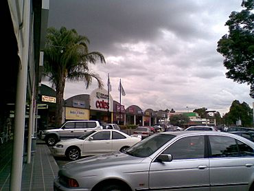
Kings Langley Shopping Centre
|
|||||||||||||||
| Population | 9,354 (2021 census) | ||||||||||||||
| Established | 1976 | ||||||||||||||
| Postcode(s) | 2147 | ||||||||||||||
| Elevation | 59 m (194 ft) | ||||||||||||||
| Location | 33 km (21 mi) NW of Sydney CBD | ||||||||||||||
| LGA(s) | Blacktown | ||||||||||||||
| State electorate(s) | Winston Hills | ||||||||||||||
| Federal Division(s) | Greenway | ||||||||||||||
|
|||||||||||||||
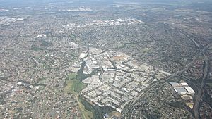
Kings Langley is a suburb in Sydney, New South Wales, Australia. It is about 28.3 kilometres north-west of the Sydney central business district (CBD). This area is part of the Blacktown City council.
The suburb stretches from Vardys Road and Sunnyholt Road in the south-west. It borders the areas of Glenwood, Bella Vista, and Baulkham Hills in the north-east. Kings Langley is known as a great place to live. A real estate website called Homely rated it as one of Sydney's best suburbs.
Contents
History of Kings Langley
The name Kings Langley comes from an early settler named Matthew Pearce (1762-1831). He named his land after Kings Langley Manor House in Hertfordshire, England. This is where he was believed to have been born.
Pearce's land was on the other side of Old Windsor Road from where the suburb is today. The name "Kings Langley" was first used for a housing project in the 1970s. It became known as a "neighbourhood" in 1976. Later, in 1987, it was officially recognised as a suburb.
Getting Around: Transport in Kings Langley
Kings Langley has good public transport options. Many bus routes connect the suburb to other major areas.
Bus Services
Hillsbus routes like 661, 706, 715, and 705 serve Kings Langley. Busways routes 743 and 718 also operate here. These buses link Kings Langley to larger suburbs such as Blacktown, Castle Hill, Seven Hills, Westmead, and Parramatta.
The suburb also has access to the North-West T-way. This is a special bus lane system. Joseph Banks and Troubadour bus stations on the T-way offer connections to:
- North Sydney (route 602X)
- Sydney CBD (routes 607X, 607N)
- Rouse Hill (routes 663, 664, 665)
- Castle Hill (route 662)
- Norwest (route 664)
- Parramatta (routes 660-665)
There is also James Cook station on the Blacktown-Parklea T-way. This station provides services to:
- Blacktown (routes 730-735)
- Castle Hill (route 730)
- Rouse Hill (routes 731, 735)
- Schofields (route 734)
Train and Metro Connections
Kings Langley is about 10 minutes away from two Sydney Trains stations: Seven Hills and Marayong.
It is also about 10 minutes from two Metro Trains Sydney stations: Bella Vista and Norwest.
Road Access
Driving to the Sydney CBD can take about 27 minutes during off-peak times. This is possible via the M2 Hills Motorway. Getting to Western Sydney became easier when the Westlink M7 opened in December 2005.
Local Services and Facilities
Kings Langley has two main shopping centres.
Shopping Centres
- Kings Langley Shopping Centre is on James Cook Drive. It has both a Coles and a Woolworths supermarket. You can also find many smaller specialty shops there.
- Solander Centre is a smaller centre. It includes a convenience store, a Speedway petrol station, and a few other specialty stores.
Healthcare
Kings Langley is conveniently located near two hospitals. These are Blacktown Hospital and the Norwest Private Hospital.
Education in Kings Langley
Kings Langley is home to several government schools.
Primary Schools
Two primary schools are located within the suburb:
- Vardys Road Primary School on Vardys Road, which opened in 1959.
- Kings Langley Public School on Isaac Smith Parade, which opened in 1981.
High Schools
There is no high school directly in Kings Langley. However, students from the suburb can attend several high schools nearby. These include:
- St Andrews in Marayong
- Patrician Brothers Blacktown
- Nagle College
- Blacktown Boys High School
- Blacktown Girls High School
- Seven Hills High School
Many families in Kings Langley also choose to send their children to high schools in nearby Baulkham Hills. Popular choices there are Crestwood High School and Model Farms High School.
Population and People
The 2021 census counted 9,354 people living in Kings Langley.
- About 1.0% of the population were Aboriginal and Torres Strait Islander people.
- Most people (69.8%) were born in Australia.
- Other common countries of birth included India (3.6%), England (3.0%), China (2.5%), New Zealand (1.6%), and the Philippines (1.0%).
- About 73.5% of people spoke only English at home.
- Other languages spoken at home included Mandarin (3.2%), Cantonese (1.5%), Tamil (1.3%), Spanish (1.2%), and Arabic (1.2%).
- The most common religions were Catholic (29.7%), No Religion (27.0%), and Anglican (14.7%).
- The unemployment rate was 3.8%.
- The average family income per week was $2,694. This was higher than the Australian average of $2,120.
See also
 In Spanish: Kings Langley (Nueva Gales del Sur) para niños
 | Bayard Rustin |
 | Jeannette Carter |
 | Jeremiah A. Brown |


