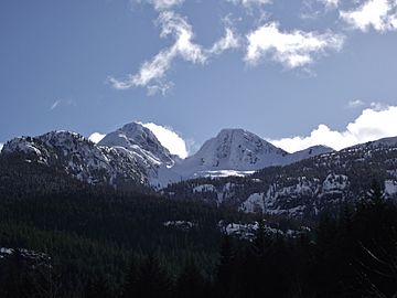
Kings Peak (British Columbia) facts for kids
Quick facts for kids Kings Peak |
|
|---|---|

Kings Peak (left) in Strathcona Provincial Park
|
|
| Highest point | |
| Elevation | 2,065 m (6,775 ft) |
| Prominence | 328 m (1,076 ft) |
| Geography | |
| Location | Vancouver Island, British Columbia, Canada |
| Parent range | Elk River Mountains |
| Topo map | NTS 92F/13 |
| Climbing | |
| First ascent | 1913 or 1914 |
Kings Peak is a cool mountain found on Vancouver Island in British Columbia, Canada. It stands tall within Strathcona Provincial Park. This park is about 25 km (16 mi) northeast of a town called Gold River. Kings Peak is also just 2 km (1 mi) north of another mountain, Elkhorn Mountain.
Contents
About Kings Peak
Kings Peak is a well-known mountain on Vancouver Island. It is a popular spot for hikers and climbers. Many people visit it each year to enjoy its beauty.
Where is Kings Peak?
This mountain is located in a beautiful natural area. It is part of the Elk River Mountains range. You can find it on Vancouver Island, which is a large island off the coast of British Columbia.
How Kings Peak Got Its Name
Kings Peak was named after two explorers. Their names were James and Michael King. They explored this area around 1910. These explorers helped map out the region. The mountain was named in their honor.
Getting to Kings Peak
Kings Peak is quite easy to reach. It is located close to Highway 28. This highway runs along the Elk River. Its easy access makes it a favorite for many adventurers.
First Climbers of Kings Peak
The first time someone officially climbed Kings Peak was a long time ago. This first climb happened in either 1913 or 1914. It was a big achievement for the climbers back then.
 | Sharif Bey |
 | Hale Woodruff |
 | Richmond Barthé |
 | Purvis Young |

