
Kings Tableland facts for kids
Quick facts for kids Kings Tableland |
|
|---|---|

The plateau of Kings Tableland stretching to the left, above Jamison Valley, centre, 2008.
|
|
| Highest point | |
| Elevation | 1,000 m (3,300 ft) |
| Geography | |

Kings Tableland
Location in New South Wales
|
|
| Parent range | Blue Mountains Range |
| Geology | |
| Mountain type | Sydney sandstone plateau |
The Kings Tableland is a large, flat area of land, like a high table, located in the amazing Blue Mountains in New South Wales, Australia. It's a special part of the landscape, offering incredible views.
Contents
Exploring Kings Tableland
Kings Tableland is a high ridge, about 1000 meters (or 3,280 feet) above sea level. It's made from old sandstone rock. You can find it just south of a town called Wentworth Falls.
This area forms the start of the Southern Escarpment. This is a long line of tall sandstone cliffs that surround several large valleys, including the Jamison, Megalong, Kanimbla, and Hartley Valleys.
Where is it?
Kings Tableland stretches from Bodington Hill all the way south to McMahons Lookout. From McMahons Lookout, you can see beautiful views over Lake Burragorang. The plateau continues for about 4.8 kilometers (or 3 miles) beyond that.
How did it get its name?
This plateau was named by Governor Macquarie after King George III. This happened a long time ago, showing its historical importance.
Getting around the Tableland
Kings Tableland extends south from Wentworth Falls and forms the eastern edge of the Jamison Valley. There are many spots along the ridge where you can enjoy fantastic views. You can reach these spots by following paths that branch off the main fire trail.
The main fire trail on top of the ridge is open to 4WD and AWD vehicles when the weather is good. It's also a popular route for mountain biking (MTB).
Along this trail, you'll find a place called Battleship Tops. This was an important meeting place for the Aboriginal people. In the past, you could see ancient ochre paintings here. Sadly, some of these paintings have been damaged over time. A survey in 2007 found four rock shelters with paintings and other important sites in the area.
Aboriginal History and Culture
A special part of Kings Tableland has been officially recognized as a significant camping and meeting place for the Aboriginal Gandangara people. This protected area includes a large sandstone rock platform. On this platform, you can see many grinding grooves and other marks made by Aboriginal people long ago.
There's also a rock shelter in this area with ancient rock art. This art is considered the oldest Aboriginal site found in the Blue Mountains region. It's unique because it has vertically engraved pictures of kangaroos and bird tracks. These artworks tell stories and show the rich history of the Gandangara people in this land.
Modern Changes and Landmarks
A road from Wentworth Falls runs along the plateau, heading north and south, leading to the McMahons Point lookout. Before the Warragamba Dam was built, this track continued down the cliffs all the way to the Cox's River area in the Burragorang Valley.
There's also a track that goes down from the western edge of the plateau into the Jamison Valley. This track originally led to an old, now unused, sewerage works below the cliffs near Katoomba. The abandoned Queen Victoria Hospital is another landmark located on Kings Tableland.
Images for kids
-
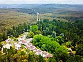
Aerial View Queen Victoria Sanitorium Kings Tableland, 2017
-
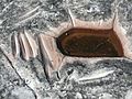
Grinding grooves, Aboriginal site, 2009.
-
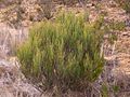
Allocasuarina nana, commonly known as the Dwarf She-Oak, found on Kings Tablelands, 2011.


