
Klondike, Oconto County, Wisconsin facts for kids
Quick facts for kids
Klondike, Wisconsin
|
|
|---|---|

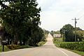
Looking south at Klondike
|
|

Klondike, Oconto County, Wisconsin
Location in Wisconsin

Klondike, Oconto County, Wisconsin
Location in the United States
|
|
| Country | |
| State | |
| County | Oconto |
| Elevation | 241 m (791 ft) |
| Time zone | UTC-6 (Central (CST)) |
| • Summer (DST) | UTC-5 (CDT) |
| Area code(s) | 920 |
| GNIS feature ID | 1567553 |
Klondike is a small, quiet place in Oconto County, Wisconsin, in the United States. It's known as an unincorporated community. This means it's a group of homes and businesses that don't have their own local government, like a city or town does. Instead, it's part of a larger area called a "town."
Klondike is located where three roads meet: Oconto County Highways ZZ, B, and Z. It's part of the town of Brazeau, Wisconsin. You can find Klondike on a map at a specific spot: its latitude is 45.068 degrees north and its longitude is -88.16 degrees west. It sits about 791 feet (or 241 meters) above sea level.
Images for kids
-
Panorama of Klondike looking west
-
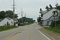
Looking south at downtown Klondike
-
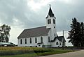
Klondike Community Church


All content from Kiddle encyclopedia articles (including the article images and facts) can be freely used under Attribution-ShareAlike license, unless stated otherwise. Cite this article:
Klondike, Oconto County, Wisconsin Facts for Kids. Kiddle Encyclopedia.