
Krumbach, Swabia (district) facts for kids
Quick facts for kids
Krumbach Schwaben
|
|
|---|---|
| Country | |
| State | Bavaria |
| Adm. region | Swabia |
| Region | Donau-Iller |
| Disbanded | 1 July 1972 |
| Capital | Krumbach (Schwaben) |
| Time zone | UTC+1 (CET) |
| • Summer (DST) | UTC+2 (CEST) |
| Vehicle registration | KRU |
Krumbach was a special area in Germany called a district. It was located in Swabia, which is a part of the state of Bavaria. Think of it like a county or a region within a larger state. The town of Krumbach was the main town, or capital, of this district. If you saw cars from this district, their licence plates would have shown "KRU".
This district existed until 1972, when some big changes happened in how regions were organized in Germany.
Contents
What Was the Krumbach District?
A district is like a local government area. The Krumbach district had 49 different towns and villages, which are called municipalities. These were places where people lived and worked.
Important Towns and Villages
The biggest places in the Krumbach district were:
- The towns of Krumbach, Bavaria and Thannhausen.
- Other important villages like Ziemetshausen, Neuburg an der Kammel, and Ursberg.
Where Was It Located?
The Krumbach district was surrounded by other districts. If you looked at a map, starting from the north and moving clockwise (like the hands of a clock), its neighbors were:
- The district of Günzburg.
- The district of Augsburg.
- The district of Schwabmünchen.
- The district of Mindelheim.
- The district of Illertissen.
- The district of Neu-Ulm.
How Did the Krumbach District Change?
In 1972, there was a big change in how districts were set up in Bavaria. The Krumbach district was combined with another district.
The Merger in 1972
On July 1, 1972, the Krumbach district joined together with the Günzburg (district) and the main town of Günzburg. This created the new, larger Günzburg district that we know today. So, the old Krumbach district became a part of this new, bigger area.
Images for kids
-
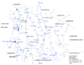
The former district of Krumbach – numbers on the map show different areas.

