
Krumovgrad facts for kids
Quick facts for kids
Krumovgrad
Крумовград
|
|||
|---|---|---|---|

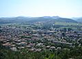
View of Krumovgrad
|
|||
|
|||

Krumovgrad
Location in Bulgaria
|
|||
| Country | Bulgaria | ||
| Province (Oblast) |
Kardzhali | ||
| Elevation | 209 m (686 ft) | ||
| Population
(13.09.2005)
|
|||
| • Total | 8,690 | ||
| Time zone | UTC+2 (EET) | ||
| • Summer (DST) | UTC+3 (EEST) | ||
| Postal Code |
6900
|
||
| Area code(s) | 03641 | ||


Krumovgrad (which is Крумовград in Bulgarian and Koşukavak in Turkish) is a town in the southern part of Bulgaria. It is located in the Kardzhali Province, right in the Eastern Rhodopes mountains. The town sits on the banks of the Krumovitsa river.
Krumovgrad is named after a very successful medieval Bulgarian ruler called Krum. The name means 'city of Krum' in Bulgarian. In 2011, a census showed that the town has a mix of people. About half are ethnic Bulgarians, and a good number are ethnic Bulgarian Turks. There are also other groups, including the Romani people. This makes Krumovgrad a place with a diverse and interesting community.
Krumovgrad Municipality
Krumovgrad is not just a town; it is also the main center of the Krumovgrad municipality. This municipality is part of the Kardzhali Province. It includes the town of Krumovgrad itself and many surrounding villages. The mayor of Krumovgrad helps lead and manage the municipality.
Geography and Climate
Krumovgrad is found in the beautiful Eastern Rhodopes mountain range. The Krumovitsa river flows through the area, adding to its natural beauty. The town is about 209 meters (686 feet) above sea level.
The climate in Krumovgrad has warm summers and cool winters. Temperatures can get quite high in July and August, sometimes reaching over 40 degrees Celsius (104 degrees Fahrenheit). Winters can be cold, with temperatures sometimes dropping below freezing. The area receives a moderate amount of rain throughout the year.
Images for kids
-
View of Krumovgrad
-
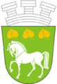
The coat of arms for Krumovgrad
-
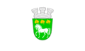
The flag of Krumovgrad
See also
 In Spanish: Krumovgrad para niños
