Kwigillingok, Alaska facts for kids
Quick facts for kids
Kwigillingok
Kuigilnguq
|
|
|---|---|

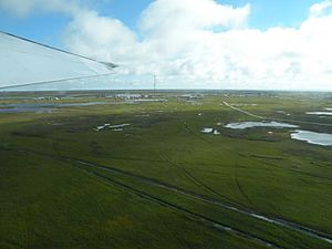
Aerial view of Kwigillingok
|
|

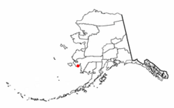
Location of Kwigillingok, Alaska
|
|
| Country | United States |
| State | Alaska |
| Census Area | Bethel |
| Area | |
| • Total | 23.83 sq mi (61.71 km2) |
| • Land | 23.79 sq mi (61.62 km2) |
| • Water | 0.04 sq mi (0.09 km2) |
| Population
(2020)
|
|
| • Total | 380 |
| • Density | 15.97/sq mi (6.17/km2) |
| Time zone | UTC-9 (Alaska (AKST)) |
| • Summer (DST) | UTC-8 (AKDT) |
| ZIP codes |
99622
|
| Area code(s) | 907 |
| FIPS code | 02-42490 |
Kwigillingok (which is Kuigilnguq in the local Yup'ik language) is a small community in Alaska, United States. It is located in the Bethel Census Area. Kwigillingok is known as a census-designated place (CDP). This means it is an area the government counts for population, but it is not an officially incorporated city or town.
In 2020, the population of Kwigillingok was 380 people. This was an increase from 321 people counted in the 2010 census.
Contents
Where is Kwigillingok Located?
Kwigillingok is found at coordinates 59.872266 degrees North and -163.166165 degrees West.
The community covers a total area of about 20.2 square miles (52.3 square kilometers). Most of this area, about 20.1 square miles (52.1 square kilometers), is land. Only a small part, about 0.1 square miles (0.3 square kilometers), is water.
How Many People Live in Kwigillingok?
| Historical population | |||
|---|---|---|---|
| Census | Pop. | %± | |
| 1920 | 104 | — | |
| 1940 | 146 | — | |
| 1950 | 245 | 67.8% | |
| 1960 | 344 | 40.4% | |
| 1970 | 148 | −57.0% | |
| 1980 | 354 | 139.2% | |
| 1990 | 278 | −21.5% | |
| 2000 | 338 | 21.6% | |
| 2010 | 321 | −5.0% | |
| 2020 | 380 | 18.4% | |
| U.S. Decennial Census | |||
Kwigillingok first appeared in the U.S. Census in 1920. Back then, it was called "Quigillingok." It was listed as an unincorporated native village.
The name changed to "Quigilinook" in 1940. By 1950, the spelling became "Kwigillingok," which is what it is today. In 1980, it was officially named a census-designated place (CDP).
Population Details from 2000
In the year 2000, there were 388 people living in Kwigillingok. These people lived in 96 households. Most of these households, 89 of them, were families.
The population density was about 16.8 people per square mile (6.5 people per square kilometer). There were 78 housing units in total.
Most of the people in Kwigillingok were Native American, making up about 97.63% of the population. About 2.07% were White.
Many households had children under 18 living with them (60.3%). About 74% of households were married couples. The average household had 4.63 people.
The population was quite young. About 39.9% of the people were under 18 years old. The median age was 26 years. This means half the people were younger than 26, and half were older.
How Do People Travel to Kwigillingok?
The main way to get to Kwigillingok is by air. The community has its own airport, called Kwigillingok Airport. There are no roads that connect Kwigillingok to other towns or cities. This makes the airport very important for travel and supplies.
Education in Kwigillingok
Students in Kwigillingok attend the K-12 Kwigillingok School. This school serves students from kindergarten all the way through 12th grade. The Lower Kuskokwim School District operates the school. As of 2021, about 144 students were enrolled there.
See also
 In Spanish: Kwigillingok (Alaska) para niños
 | Tommie Smith |
 | Simone Manuel |
 | Shani Davis |
 | Simone Biles |
 | Alice Coachman |

