Kyffhäuserkreis Rural District facts for kids
Quick facts for kids
Kyffhäuserkreis
|
|
|---|---|
 |
|
| Country | |
| State | Thuringia |
| Capital | Sondershausen |
| Area | |
| • Total | 1,035 km2 (400 sq mi) |
| Population
(2002)
|
|
| • Total | 91,940 |
| • Density | 88.83/km2 (230.07/sq mi) |
| Time zone | UTC+1 (CET) |
| • Summer (DST) | UTC+2 (CEST) |
| Vehicle registration | KYF |
| Website | http://www.kyffhaeuser.de |
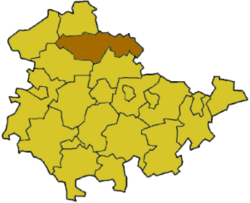
The Kyffhäuserkreis is a cool place in the northern part of Thuringia, Germany. It's a "rural district," which means it's an area with many towns and villages, but it's not a huge city. It's named after the famous Kyffhäuser mountains, which have some awesome history and legends!
Contents
Exploring the Kyffhäuserkreis History
Ancient Legends and Emperors
Long, long ago, in the 12th century, a big castle stood on the Kyffhäuser mountains. This castle was built when Emperor Frederick I (also known as Barbarossa) was in charge. A local legend says that the emperor didn't really die. Instead, he just went to sleep inside this castle, waiting to wake up when Germany needs him most!
Changes Over the Centuries
For a long time, starting in 1579, this region was part of Saxony. But after the year 1815, things changed. The area was split up between two different parts of Germany: the Prussian Province of Saxony and Schwarzburg-Sondershausen. Imagine your town suddenly belonging to a different state!
Modern District Formation
Later, in 1952, the government of East Germany created two smaller districts here: Artern and Sondershausen. These two districts stayed separate for many years. Then, in 1994, they decided to join them together. This created the Kyffhäuserkreis as we know it today. Only a few small towns from the old districts joined other nearby areas.
Kyffhäuserkreis Partnerships
Friends Across Germany
The Kyffhäuserkreis has a special "partnership" with another district in Germany called Ahrweiler. This district is located in a different state, Rhineland-Palatinate. This partnership is like a friendship between two regions. It was actually started way back in 1990 with the old district of Artern, before it became part of Kyffhäuserkreis.
Geography of Kyffhäuserkreis
Mountains and Rivers
As you might guess, the district gets its name from the Kyffhäuser mountains. These mountains are a very important landmark in the area. The main river flowing through the eastern part of the district is the Unstrut. Rivers are super important for nature and for people living nearby!
Understanding the Kyffhäuserkreis Coat of Arms
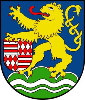
The coat of arms is like a special symbol for the district. It tells a story about its history and geography.
- The main part of the symbol is a lion. This lion belonged to the Counts of Schwarzburg, who were powerful rulers in most of this area a long time ago.
- The lion is holding a shield. On this shield, you can see the symbols of the Counts of Mansfeld. They owned the area around Artern in the 18th century.
- At the bottom, there are three green hills. These hills show that the district has lots of mountains and forests.
- There are also two wavy lines. The bigger wavy line stands for the Unstrut river, which is the main river here. The smaller wavy line represents the Wipper river.
Main Towns in Kyffhäuserkreis
The Kyffhäuserkreis is home to many interesting towns and smaller communities. Here are some of the most important towns:
- Artern
- Bad Frankenhausen
- Ebeleben
- Großenehrich
- Roßleben
- Sondershausen (This is the capital of the district!)
- Wiehe
 | Leon Lynch |
 | Milton P. Webster |
 | Ferdinand Smith |


